You are here: Home > Network List > AV - Alaska Volcano Observatory Stations List
> Station PLBL Mt. Peulik Volcano, Alaska > Earthquake Result Viewer
PLBL Mt. Peulik Volcano, Alaska - Earthquake Result Viewer
| Earthquake location: |
Solomon Islands |
| Earthquake latitude/longitude: |
-10.1/161.6 |
| Earthquake time(UTC): |
2018/09/09 (252) 19:31:36 GMT |
| Earthquake Depth: |
54 km |
| Earthquake Magnitude: |
6.7 Mi |
| Earthquake Catalog/Contributor: |
NEIC PDE/at |
|
| Network: |
AV Alaska Volcano Observatory |
| Station: |
PLBL Mt. Peulik Volcano, Alaska |
| Lat/Lon: |
57.70 N/156.82 W |
| Elevation: |
461 m |
|
| Distance: |
75.6 deg |
| Az: |
21.585 deg |
| Baz: |
222.428 deg |
| Ray Param: |
0.05144781 |
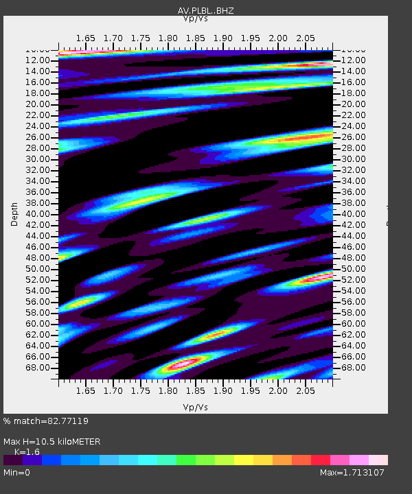
| Estimated Moho Depth: |
10.5 km |
| Estimated Crust Vp/Vs: |
1.60 |
| Assumed Crust Vp: |
6.1 km/s |
| Estimated Crust Vs: |
3.812 km/s |
| Estimated Crust Poisson's Ratio: |
0.18 |
|
| Radial Match: |
82.77119 % |
| Radial Bump: |
400 |
| Transverse Match: |
80.36172 % |
| Transverse Bump: |
400 |
| SOD ConfigId: |
13570011 |
| Insert Time: |
2019-05-01 04:55:26.625 +0000 |
| GWidth: |
2.5 |
| Max Bumps: |
400 |
| Tol: |
0.001 |
|
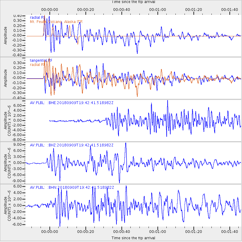
Signal To Noise
| Channel | StoN | STA | LTA |
| AV:PLBL: :BHZ:20180909T19:42:41.518982Z | 16.468771 | 3.4882444E-6 | 2.1180962E-7 |
| AV:PLBL: :BHN:20180909T19:42:41.518982Z | 8.023311 | 1.8215902E-6 | 2.2703722E-7 |
| AV:PLBL: :BHE:20180909T19:42:41.518982Z | 9.060032 | 1.95772E-6 | 2.1608314E-7 |
| Arrivals |
| Ps | 1.1 SECOND |
| PpPs | 4.3 SECOND |
| PsPs/PpSs | 5.4 SECOND |


