You are here: Home > Network List > CN - Canadian National Seismograph Network Stations List
> Station INK INUVIK, NT > Earthquake Result Viewer
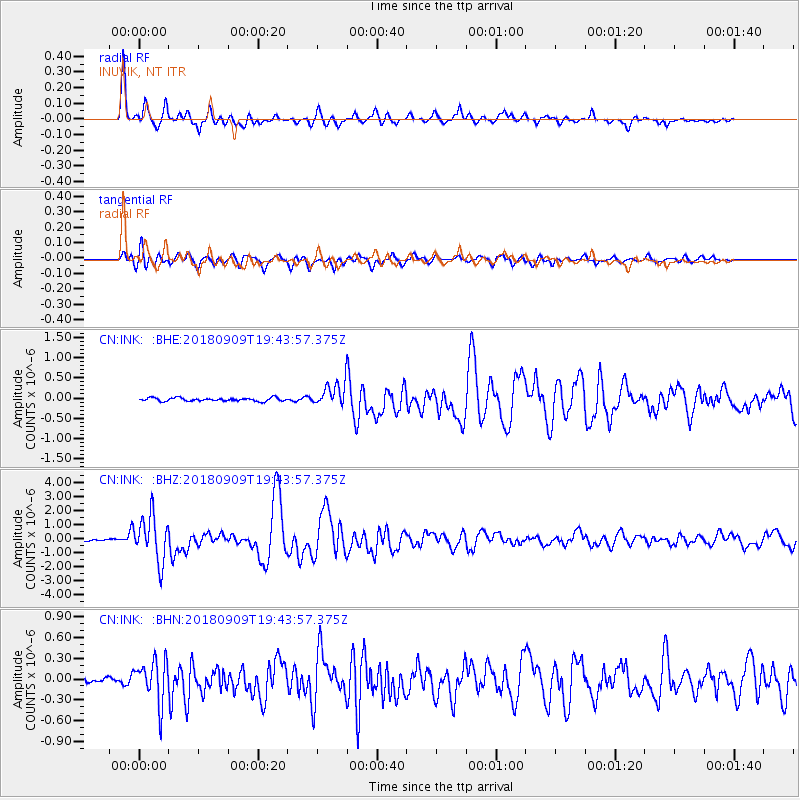
INK INUVIK, NT - Earthquake Result Viewer
*The percent match for this event was below the threshold and hence no stack was calculated.
| Earthquake location: |
Solomon Islands |
| Earthquake latitude/longitude: |
-10.1/161.6 |
| Earthquake time(UTC): |
2018/09/09 (252) 19:31:36 GMT |
| Earthquake Depth: |
54 km |
| Earthquake Magnitude: |
6.7 Mi |
| Earthquake Catalog/Contributor: |
NEIC PDE/at |
|
| Network: |
CN Canadian National Seismograph Network |
| Station: |
INK INUVIK, NT |
| Lat/Lon: |
68.31 N/133.53 W |
| Elevation: |
44 m |
|
| Distance: |
90.4 deg |
| Az: |
19.671 deg |
| Baz: |
243.069 deg |
| Ray Param: |
$rayparam |
*The percent match for this event was below the threshold and hence was not used in the summary stack. |
|
| Radial Match: |
95.50618 % |
| Radial Bump: |
400 |
| Transverse Match: |
90.23885 % |
| Transverse Bump: |
400 |
| SOD ConfigId: |
13570011 |
| Insert Time: |
2019-05-01 04:57:23.679 +0000 |
| GWidth: |
2.5 |
| Max Bumps: |
400 |
| Tol: |
0.001 |
|
Signal To Noise
| Channel | StoN | STA | LTA |
| CN:INK: :BHZ:20180909T19:43:57.375Z | 25.32059 | 1.6191941E-6 | 6.3947724E-8 |
| CN:INK: :BHN:20180909T19:43:57.375Z | 7.5275636 | 3.108799E-7 | 4.1298875E-8 |
| CN:INK: :BHE:20180909T19:43:57.375Z | 12.427636 | 4.9255254E-7 | 3.9633647E-8 |
| Arrivals |
| Ps | |
| PpPs | |
| PsPs/PpSs | |


