You are here: Home > Network List > TA - USArray Transportable Network (new EarthScope stations) Stations List
> Station A22K Sinclair Lake, AK, USA > Earthquake Result Viewer
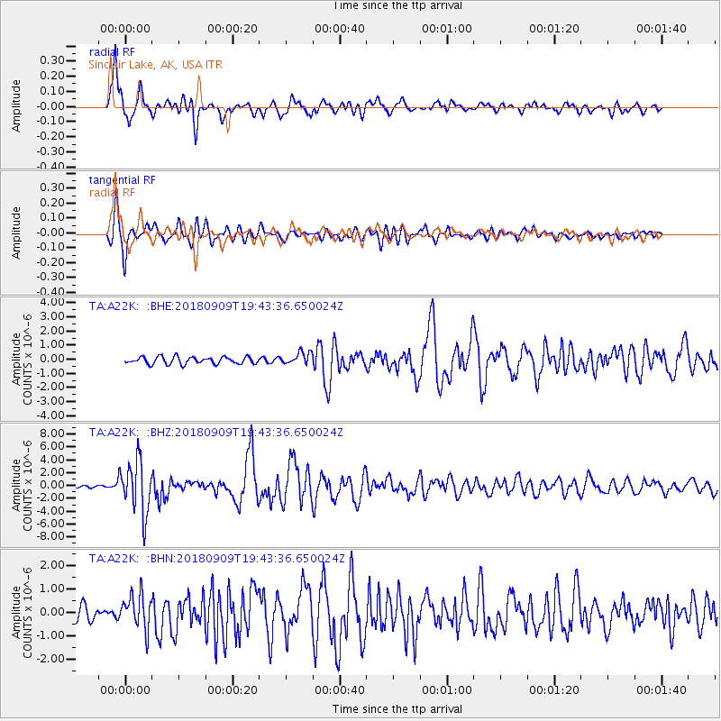
A22K Sinclair Lake, AK, USA - Earthquake Result Viewer
*The percent match for this event was below the threshold and hence no stack was calculated.
| Earthquake location: |
Solomon Islands |
| Earthquake latitude/longitude: |
-10.1/161.6 |
| Earthquake time(UTC): |
2018/09/09 (252) 19:31:36 GMT |
| Earthquake Depth: |
54 km |
| Earthquake Magnitude: |
6.7 Mi |
| Earthquake Catalog/Contributor: |
NEIC PDE/at |
|
| Network: |
TA USArray Transportable Network (new EarthScope stations) |
| Station: |
A22K Sinclair Lake, AK, USA |
| Lat/Lon: |
71.00 N/154.97 W |
| Elevation: |
6.0 m |
|
| Distance: |
86.0 deg |
| Az: |
13.041 deg |
| Baz: |
222.73 deg |
| Ray Param: |
$rayparam |
*The percent match for this event was below the threshold and hence was not used in the summary stack. |
|
| Radial Match: |
94.34858 % |
| Radial Bump: |
400 |
| Transverse Match: |
90.31673 % |
| Transverse Bump: |
400 |
| SOD ConfigId: |
13570011 |
| Insert Time: |
2019-05-01 05:00:03.950 +0000 |
| GWidth: |
2.5 |
| Max Bumps: |
400 |
| Tol: |
0.001 |
|
Signal To Noise
| Channel | StoN | STA | LTA |
| TA:A22K: :BHZ:20180909T19:43:36.650024Z | 19.55956 | 4.027181E-6 | 2.0589323E-7 |
| TA:A22K: :BHN:20180909T19:43:36.650024Z | 3.646821 | 7.447883E-7 | 2.0422945E-7 |
| TA:A22K: :BHE:20180909T19:43:36.650024Z | 4.051557 | 1.0300662E-6 | 2.5423958E-7 |
| Arrivals |
| Ps | |
| PpPs | |
| PsPs/PpSs | |


