You are here: Home > Network List > TA - USArray Transportable Network (new EarthScope stations) Stations List
> Station A21K Barrow, AK, USA > Earthquake Result Viewer
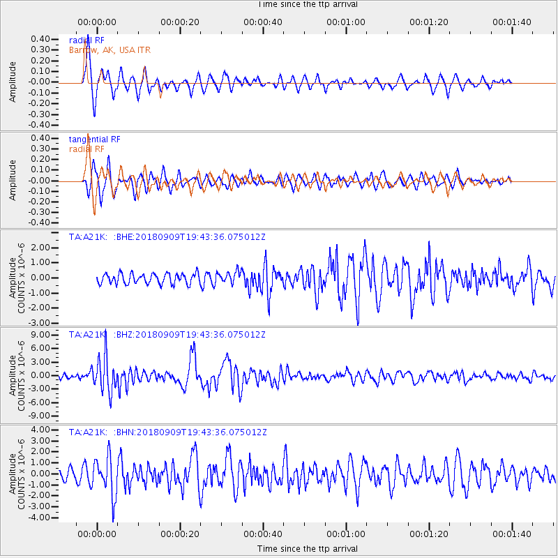
A21K Barrow, AK, USA - Earthquake Result Viewer
*The percent match for this event was below the threshold and hence no stack was calculated.
| Earthquake location: |
Solomon Islands |
| Earthquake latitude/longitude: |
-10.1/161.6 |
| Earthquake time(UTC): |
2018/09/09 (252) 19:31:36 GMT |
| Earthquake Depth: |
54 km |
| Earthquake Magnitude: |
6.7 Mi |
| Earthquake Catalog/Contributor: |
NEIC PDE/at |
|
| Network: |
TA USArray Transportable Network (new EarthScope stations) |
| Station: |
A21K Barrow, AK, USA |
| Lat/Lon: |
71.32 N/156.62 W |
| Elevation: |
577 m |
|
| Distance: |
85.9 deg |
| Az: |
12.429 deg |
| Baz: |
221.133 deg |
| Ray Param: |
$rayparam |
*The percent match for this event was below the threshold and hence was not used in the summary stack. |
|
| Radial Match: |
82.277176 % |
| Radial Bump: |
390 |
| Transverse Match: |
84.47783 % |
| Transverse Bump: |
400 |
| SOD ConfigId: |
13570011 |
| Insert Time: |
2019-05-01 05:00:03.958 +0000 |
| GWidth: |
2.5 |
| Max Bumps: |
400 |
| Tol: |
0.001 |
|
Signal To Noise
| Channel | StoN | STA | LTA |
| TA:A21K: :BHZ:20180909T19:43:36.075012Z | 10.388707 | 3.9337074E-6 | 3.7865223E-7 |
| TA:A21K: :BHN:20180909T19:43:36.075012Z | 4.3151927 | 1.7846032E-6 | 4.1356282E-7 |
| TA:A21K: :BHE:20180909T19:43:36.075012Z | 1.5165377 | 5.356561E-7 | 3.5320988E-7 |
| Arrivals |
| Ps | |
| PpPs | |
| PsPs/PpSs | |


