You are here: Home > Network List > TA - USArray Transportable Network (new EarthScope stations) Stations List
> Station D23K Nanushuk River, AK USA > Earthquake Result Viewer
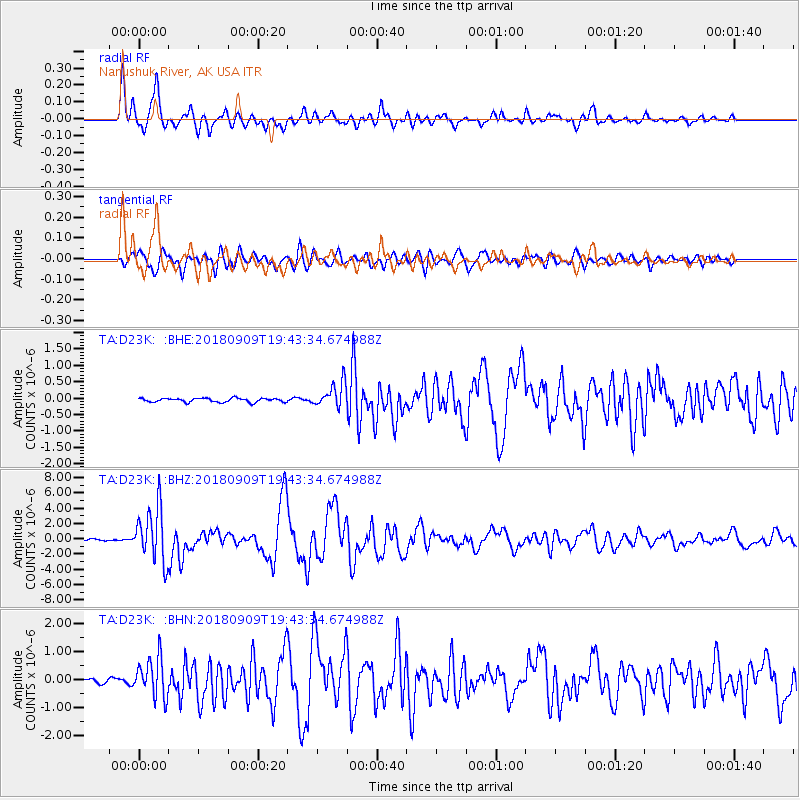
D23K Nanushuk River, AK USA - Earthquake Result Viewer
*The percent match for this event was below the threshold and hence no stack was calculated.
| Earthquake location: |
Solomon Islands |
| Earthquake latitude/longitude: |
-10.1/161.6 |
| Earthquake time(UTC): |
2018/09/09 (252) 19:31:36 GMT |
| Earthquake Depth: |
54 km |
| Earthquake Magnitude: |
6.7 Mi |
| Earthquake Catalog/Contributor: |
NEIC PDE/at |
|
| Network: |
TA USArray Transportable Network (new EarthScope stations) |
| Station: |
D23K Nanushuk River, AK USA |
| Lat/Lon: |
68.97 N/150.68 W |
| Elevation: |
406 m |
|
| Distance: |
85.6 deg |
| Az: |
15.539 deg |
| Baz: |
226.945 deg |
| Ray Param: |
$rayparam |
*The percent match for this event was below the threshold and hence was not used in the summary stack. |
|
| Radial Match: |
93.94143 % |
| Radial Bump: |
400 |
| Transverse Match: |
90.566 % |
| Transverse Bump: |
400 |
| SOD ConfigId: |
13570011 |
| Insert Time: |
2019-05-01 05:00:20.528 +0000 |
| GWidth: |
2.5 |
| Max Bumps: |
400 |
| Tol: |
0.001 |
|
Signal To Noise
| Channel | StoN | STA | LTA |
| TA:D23K: :BHZ:20180909T19:43:34.674988Z | 40.455208 | 3.5679811E-6 | 8.819585E-8 |
| TA:D23K: :BHN:20180909T19:43:34.674988Z | 8.30766 | 6.991898E-7 | 8.416206E-8 |
| TA:D23K: :BHE:20180909T19:43:34.674988Z | 12.865432 | 7.828146E-7 | 6.0846354E-8 |
| Arrivals |
| Ps | |
| PpPs | |
| PsPs/PpSs | |


