You are here: Home > Network List > TA - USArray Transportable Network (new EarthScope stations) Stations List
> Station G22K Bettles, AK, USA > Earthquake Result Viewer
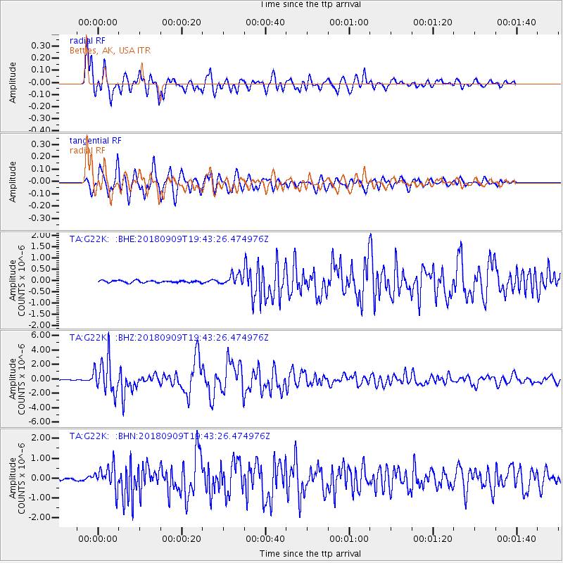
G22K Bettles, AK, USA - Earthquake Result Viewer
*The percent match for this event was below the threshold and hence no stack was calculated.
| Earthquake location: |
Solomon Islands |
| Earthquake latitude/longitude: |
-10.1/161.6 |
| Earthquake time(UTC): |
2018/09/09 (252) 19:31:36 GMT |
| Earthquake Depth: |
54 km |
| Earthquake Magnitude: |
6.7 Mi |
| Earthquake Catalog/Contributor: |
NEIC PDE/at |
|
| Network: |
TA USArray Transportable Network (new EarthScope stations) |
| Station: |
G22K Bettles, AK, USA |
| Lat/Lon: |
66.92 N/151.51 W |
| Elevation: |
205 m |
|
| Distance: |
84.0 deg |
| Az: |
16.823 deg |
| Baz: |
226.296 deg |
| Ray Param: |
$rayparam |
*The percent match for this event was below the threshold and hence was not used in the summary stack. |
|
| Radial Match: |
94.78206 % |
| Radial Bump: |
400 |
| Transverse Match: |
92.67721 % |
| Transverse Bump: |
400 |
| SOD ConfigId: |
13570011 |
| Insert Time: |
2019-05-01 05:00:48.912 +0000 |
| GWidth: |
2.5 |
| Max Bumps: |
400 |
| Tol: |
0.001 |
|
Signal To Noise
| Channel | StoN | STA | LTA |
| TA:G22K: :BHZ:20180909T19:43:26.474976Z | 36.691315 | 2.421279E-6 | 6.599052E-8 |
| TA:G22K: :BHN:20180909T19:43:26.474976Z | 8.452528 | 5.9824487E-7 | 7.0777034E-8 |
| TA:G22K: :BHE:20180909T19:43:26.474976Z | 12.693195 | 5.9476804E-7 | 4.6857235E-8 |
| Arrivals |
| Ps | |
| PpPs | |
| PsPs/PpSs | |


