You are here: Home > Network List > TA - USArray Transportable Network (new EarthScope stations) Stations List
> Station H16K Elim, AK, USA > Earthquake Result Viewer
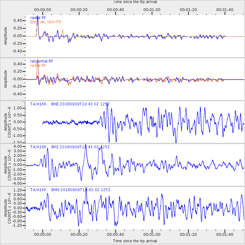
H16K Elim, AK, USA - Earthquake Result Viewer
*The percent match for this event was below the threshold and hence no stack was calculated.
| Earthquake location: |
Solomon Islands |
| Earthquake latitude/longitude: |
-10.1/161.6 |
| Earthquake time(UTC): |
2018/09/09 (252) 19:31:36 GMT |
| Earthquake Depth: |
54 km |
| Earthquake Magnitude: |
6.7 Mi |
| Earthquake Catalog/Contributor: |
NEIC PDE/at |
|
| Network: |
TA USArray Transportable Network (new EarthScope stations) |
| Station: |
H16K Elim, AK, USA |
| Lat/Lon: |
64.64 N/162.24 W |
| Elevation: |
216 m |
|
| Distance: |
79.3 deg |
| Az: |
14.987 deg |
| Baz: |
216.246 deg |
| Ray Param: |
$rayparam |
*The percent match for this event was below the threshold and hence was not used in the summary stack. |
|
| Radial Match: |
95.21125 % |
| Radial Bump: |
400 |
| Transverse Match: |
86.824265 % |
| Transverse Bump: |
400 |
| SOD ConfigId: |
13570011 |
| Insert Time: |
2019-05-01 05:00:56.065 +0000 |
| GWidth: |
2.5 |
| Max Bumps: |
400 |
| Tol: |
0.001 |
|
Signal To Noise
| Channel | StoN | STA | LTA |
| TA:H16K: :BHZ:20180909T19:43:02.125Z | 35.192776 | 1.9030992E-6 | 5.4076416E-8 |
| TA:H16K: :BHN:20180909T19:43:02.125Z | 6.8246274 | 5.23138E-7 | 7.6654445E-8 |
| TA:H16K: :BHE:20180909T19:43:02.125Z | 10.780549 | 7.16571E-7 | 6.646887E-8 |
| Arrivals |
| Ps | |
| PpPs | |
| PsPs/PpSs | |


