You are here: Home > Network List > TA - USArray Transportable Network (new EarthScope stations) Stations List
> Station H25L Birch Creek, AK, USA > Earthquake Result Viewer
H25L Birch Creek, AK, USA - Earthquake Result Viewer
| Earthquake location: |
Solomon Islands |
| Earthquake latitude/longitude: |
-10.1/161.6 |
| Earthquake time(UTC): |
2018/09/09 (252) 19:31:36 GMT |
| Earthquake Depth: |
54 km |
| Earthquake Magnitude: |
6.7 Mi |
| Earthquake Catalog/Contributor: |
NEIC PDE/at |
|
| Network: |
TA USArray Transportable Network (new EarthScope stations) |
| Station: |
H25L Birch Creek, AK, USA |
| Lat/Lon: |
66.27 N/145.82 W |
| Elevation: |
144 m |
|
| Distance: |
85.2 deg |
| Az: |
18.818 deg |
| Baz: |
231.699 deg |
| Ray Param: |
0.04480589 |
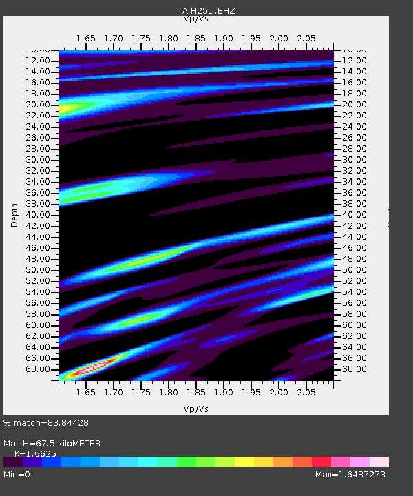
| Estimated Moho Depth: |
67.5 km |
| Estimated Crust Vp/Vs: |
1.66 |
| Assumed Crust Vp: |
6.522 km/s |
| Estimated Crust Vs: |
3.923 km/s |
| Estimated Crust Poisson's Ratio: |
0.22 |
|
| Radial Match: |
83.84428 % |
| Radial Bump: |
400 |
| Transverse Match: |
82.60295 % |
| Transverse Bump: |
400 |
| SOD ConfigId: |
13570011 |
| Insert Time: |
2019-05-01 05:01:01.610 +0000 |
| GWidth: |
2.5 |
| Max Bumps: |
400 |
| Tol: |
0.001 |
|

Signal To Noise
| Channel | StoN | STA | LTA |
| TA:H25L: :BHZ:20180909T19:43:32.950012Z | 8.257384 | 1.1978159E-6 | 1.4505997E-7 |
| TA:H25L: :BHN:20180909T19:43:32.950012Z | 1.478727 | 3.009709E-7 | 2.0353377E-7 |
| TA:H25L: :BHE:20180909T19:43:32.950012Z | 2.1275458 | 4.315755E-7 | 2.0285134E-7 |
| Arrivals |
| Ps | 7.0 SECOND |
| PpPs | 27 SECOND |
| PsPs/PpSs | 34 SECOND |


