You are here: Home > Network List > TA - USArray Transportable Network (new EarthScope stations) Stations List
> Station M31M Drury Creek, Yukon, CA > Earthquake Result Viewer
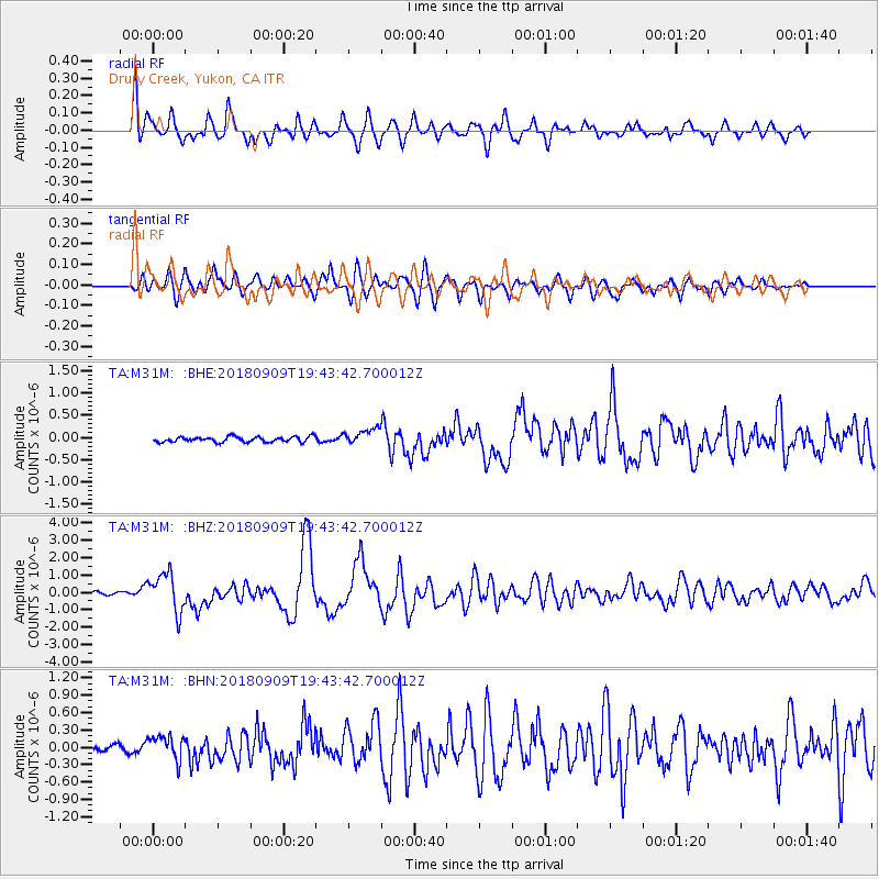
M31M Drury Creek, Yukon, CA - Earthquake Result Viewer
*The percent match for this event was below the threshold and hence no stack was calculated.
| Earthquake location: |
Solomon Islands |
| Earthquake latitude/longitude: |
-10.1/161.6 |
| Earthquake time(UTC): |
2018/09/09 (252) 19:31:36 GMT |
| Earthquake Depth: |
54 km |
| Earthquake Magnitude: |
6.7 Mi |
| Earthquake Catalog/Contributor: |
NEIC PDE/at |
|
| Network: |
TA USArray Transportable Network (new EarthScope stations) |
| Station: |
M31M Drury Creek, Yukon, CA |
| Lat/Lon: |
62.20 N/134.39 W |
| Elevation: |
639 m |
|
| Distance: |
87.2 deg |
| Az: |
24.954 deg |
| Baz: |
242.394 deg |
| Ray Param: |
$rayparam |
*The percent match for this event was below the threshold and hence was not used in the summary stack. |
|
| Radial Match: |
84.21245 % |
| Radial Bump: |
400 |
| Transverse Match: |
81.64465 % |
| Transverse Bump: |
400 |
| SOD ConfigId: |
13570011 |
| Insert Time: |
2019-05-01 05:01:47.869 +0000 |
| GWidth: |
2.5 |
| Max Bumps: |
400 |
| Tol: |
0.001 |
|
Signal To Noise
| Channel | StoN | STA | LTA |
| TA:M31M: :BHZ:20180909T19:43:42.700012Z | 12.774332 | 1.1112074E-6 | 8.698752E-8 |
| TA:M31M: :BHN:20180909T19:43:42.700012Z | 3.5097477 | 2.0657144E-7 | 5.8856493E-8 |
| TA:M31M: :BHE:20180909T19:43:42.700012Z | 4.917605 | 2.915425E-7 | 5.9285465E-8 |
| Arrivals |
| Ps | |
| PpPs | |
| PsPs/PpSs | |


