You are here: Home > Network List > AE - Arizona Broadband Seismic Network Stations List
> Station DUN6 Lazy B Ranch > Earthquake Result Viewer
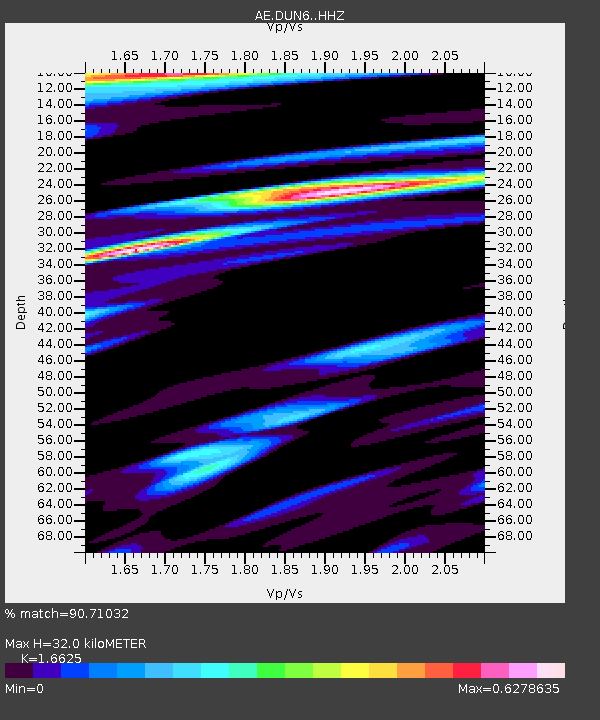
DUN6 Lazy B Ranch - Earthquake Result Viewer
| Earthquake location: |
Kermadec Islands Region |
| Earthquake latitude/longitude: |
-31.8/-179.3 |
| Earthquake time(UTC): |
2018/09/10 (253) 04:19:02 GMT |
| Earthquake Depth: |
111 km |
| Earthquake Magnitude: |
6.9 mww |
| Earthquake Catalog/Contributor: |
NEIC PDE/us |
|
| Network: |
AE Arizona Broadband Seismic Network |
| Station: |
DUN6 Lazy B Ranch |
| Lat/Lon: |
32.55 N/109.09 W |
| Elevation: |
1259 m |
|
| Distance: |
92.2 deg |
| Az: |
52.692 deg |
| Baz: |
233.281 deg |
| Ray Param: |
0.04144667 |
| Estimated Moho Depth: |
32.0 km |
| Estimated Crust Vp/Vs: |
1.66 |
| Assumed Crust Vp: |
6.276 km/s |
| Estimated Crust Vs: |
3.775 km/s |
| Estimated Crust Poisson's Ratio: |
0.22 |
|
| Radial Match: |
90.71032 % |
| Radial Bump: |
400 |
| Transverse Match: |
78.29641 % |
| Transverse Bump: |
400 |
| SOD ConfigId: |
13570011 |
| Insert Time: |
2019-05-01 05:05:06.098 +0000 |
| GWidth: |
2.5 |
| Max Bumps: |
400 |
| Tol: |
0.001 |
|

Signal To Noise
| Channel | StoN | STA | LTA |
| AE:DUN6: :HHZ:20180910T04:31:27.90999Z | 22.360954 | 1.111981E-5 | 4.9728686E-7 |
| AE:DUN6: :HHN:20180910T04:31:27.90999Z | 4.826081 | 2.1954538E-6 | 4.5491444E-7 |
| AE:DUN6: :HHE:20180910T04:31:27.90999Z | 7.9195647 | 2.6058344E-6 | 3.290376E-7 |
| Arrivals |
| Ps | 3.4 SECOND |
| PpPs | 13 SECOND |
| PsPs/PpSs | 17 SECOND |


