You are here: Home > Network List > AK - Alaska Regional Network Stations List
> Station CHN Chernabura Island, AK, USA > Earthquake Result Viewer
CHN Chernabura Island, AK, USA - Earthquake Result Viewer
| Earthquake location: |
Kermadec Islands Region |
| Earthquake latitude/longitude: |
-31.8/-179.3 |
| Earthquake time(UTC): |
2018/09/10 (253) 04:19:02 GMT |
| Earthquake Depth: |
111 km |
| Earthquake Magnitude: |
6.9 mww |
| Earthquake Catalog/Contributor: |
NEIC PDE/us |
|
| Network: |
AK Alaska Regional Network |
| Station: |
CHN Chernabura Island, AK, USA |
| Lat/Lon: |
54.83 N/159.59 W |
| Elevation: |
71 m |
|
| Distance: |
88.0 deg |
| Az: |
11.278 deg |
| Baz: |
196.72 deg |
| Ray Param: |
0.04269011 |
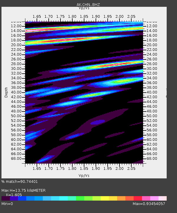
| Estimated Moho Depth: |
13.75 km |
| Estimated Crust Vp/Vs: |
1.61 |
| Assumed Crust Vp: |
5.989 km/s |
| Estimated Crust Vs: |
3.732 km/s |
| Estimated Crust Poisson's Ratio: |
0.18 |
|
| Radial Match: |
90.74401 % |
| Radial Bump: |
400 |
| Transverse Match: |
84.37539 % |
| Transverse Bump: |
400 |
| SOD ConfigId: |
13570011 |
| Insert Time: |
2019-05-01 05:05:24.082 +0000 |
| GWidth: |
2.5 |
| Max Bumps: |
400 |
| Tol: |
0.001 |
|

Signal To Noise
| Channel | StoN | STA | LTA |
| AK:CHN: :BHZ:20180910T04:31:08.107988Z | 57.192574 | 1.5877498E-5 | 2.7761467E-7 |
| AK:CHN: :BHN:20180910T04:31:08.107988Z | 14.283308 | 3.2513665E-6 | 2.27634E-7 |
| AK:CHN: :BHE:20180910T04:31:08.107988Z | 13.551317 | 2.630128E-6 | 1.9408652E-7 |
| Arrivals |
| Ps | 1.4 SECOND |
| PpPs | 5.9 SECOND |
| PsPs/PpSs | 7.3 SECOND |


