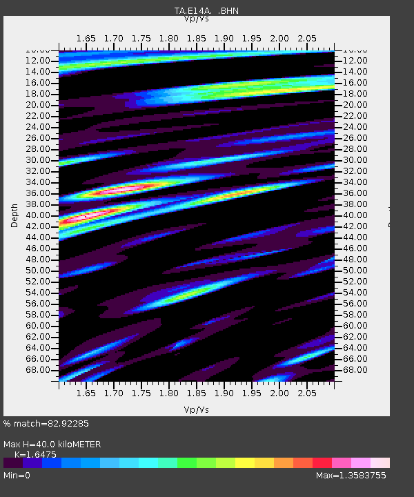
E14A Clinton, MT, USA - Earthquake Result Viewer

Earthquake location: Andreanof Islands, Aleutian Is.
Earthquake latitude/longitude: 52.2/-175.7
Earthquake time(UTC): 2008/08/07 (220) 18:30:03 GMT
Earthquake Depth: 12 km
Earthquake Magnitude: 5.6 MB, 5.5 MS, 5.8 MW, 5.8 MW
Earthquake Catalog/Contributor: WHDF/NEIC
Network: TA USArray Transportable Network (new EarthScope stations)
Station: E14A Clinton, MT, USA
Lat/Lon: 46.42 N/113.49 W
Elevation: 1675 m
Distance: 39.8 deg
Az: 72.757 deg
Baz: 301.807 deg
Ray Param: 0.07474812
Estimated Moho Depth: 40.0 km
Estimated Crust Vp/Vs: 1.65
Assumed Crust Vp: 6.353 km/s
Estimated Crust Vs: 3.856 km/s
Estimated Crust Poisson's Ratio: 0.21
Radial Match: 82.92285 %
Radial Bump: 400
Transverse Match: 74.82579 %
Transverse Bump: 400
SOD ConfigId: 2504
Insert Time: 2010-03-06 15:40:58.983 +0000
GWidth: 2.5
Max Bumps: 400
Tol: 0.001

Signal To Noise

ChannelStoNSTALTA
TA:E14A: :BHN:20080807T18:37:05.325005Z22.0392886.326131E-72.870388E-8
TA:E14A: :BHE:20080807T18:37:05.325005Z9.3029933.502271E-73.7646718E-8
TA:E14A: :BHZ:20080807T18:37:05.325005Z7.2896882.583612E-73.544201E-8
Arrivals
Ps4.4 SECOND
PpPs15 SECOND
PsPs/PpSs20 SECOND