You are here: Home > Network List > AK - Alaska Regional Network Stations List
> Station SII Sitkinak Island Coast Guard > Earthquake Result Viewer
SII Sitkinak Island Coast Guard - Earthquake Result Viewer
| Earthquake location: |
Kermadec Islands Region |
| Earthquake latitude/longitude: |
-31.8/-179.3 |
| Earthquake time(UTC): |
2018/09/10 (253) 04:19:02 GMT |
| Earthquake Depth: |
111 km |
| Earthquake Magnitude: |
6.9 mww |
| Earthquake Catalog/Contributor: |
NEIC PDE/us |
|
| Network: |
AK Alaska Regional Network |
| Station: |
SII Sitkinak Island Coast Guard |
| Lat/Lon: |
56.56 N/154.18 W |
| Elevation: |
465 m |
|
| Distance: |
90.6 deg |
| Az: |
13.609 deg |
| Baz: |
201.206 deg |
| Ray Param: |
0.04163889 |
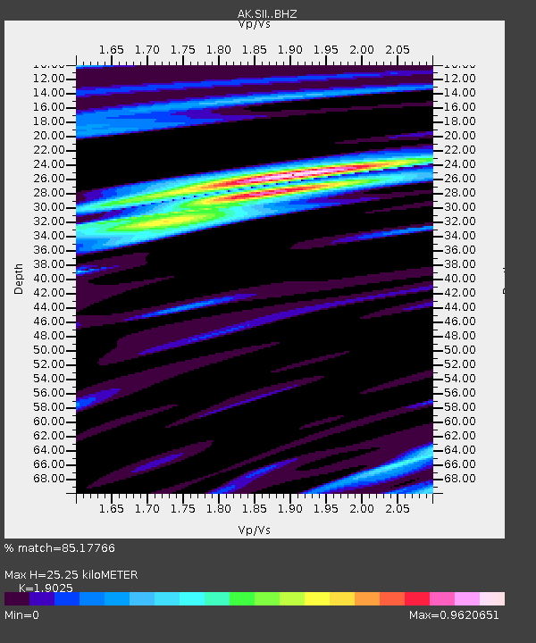
| Estimated Moho Depth: |
25.25 km |
| Estimated Crust Vp/Vs: |
1.90 |
| Assumed Crust Vp: |
6.24 km/s |
| Estimated Crust Vs: |
3.28 km/s |
| Estimated Crust Poisson's Ratio: |
0.31 |
|
| Radial Match: |
85.17766 % |
| Radial Bump: |
400 |
| Transverse Match: |
67.524956 % |
| Transverse Bump: |
400 |
| SOD ConfigId: |
13570011 |
| Insert Time: |
2019-05-01 05:06:25.402 +0000 |
| GWidth: |
2.5 |
| Max Bumps: |
400 |
| Tol: |
0.001 |
|

Signal To Noise
| Channel | StoN | STA | LTA |
| AK:SII: :BHZ:20180910T04:31:20.388018Z | 21.75492 | 9.065249E-6 | 4.1669884E-7 |
| AK:SII: :BHN:20180910T04:31:20.388018Z | 4.094134 | 2.3424418E-6 | 5.721459E-7 |
| AK:SII: :BHE:20180910T04:31:20.388018Z | 2.5800476 | 1.1734252E-6 | 4.5480758E-7 |
| Arrivals |
| Ps | 3.7 SECOND |
| PpPs | 12 SECOND |
| PsPs/PpSs | 15 SECOND |


