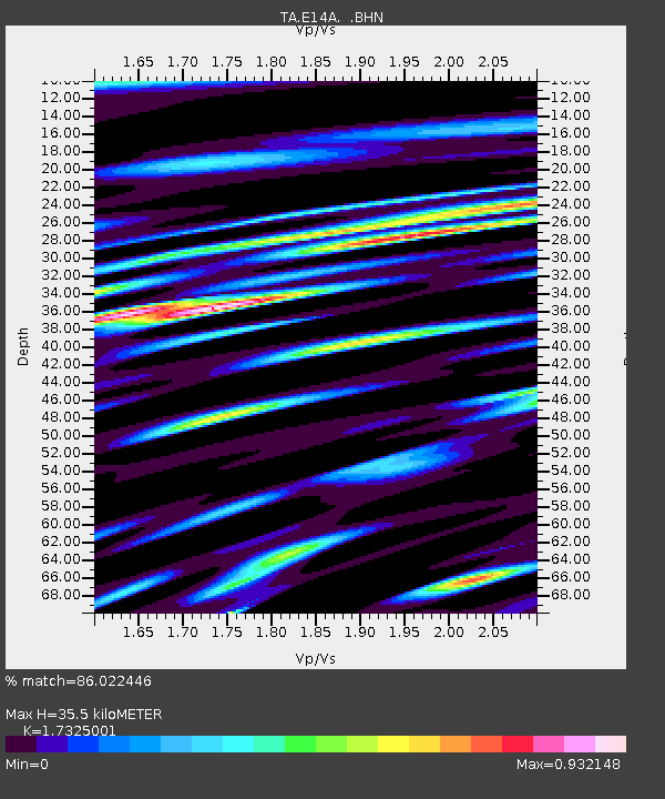
E14A Clinton, MT, USA - Earthquake Result Viewer
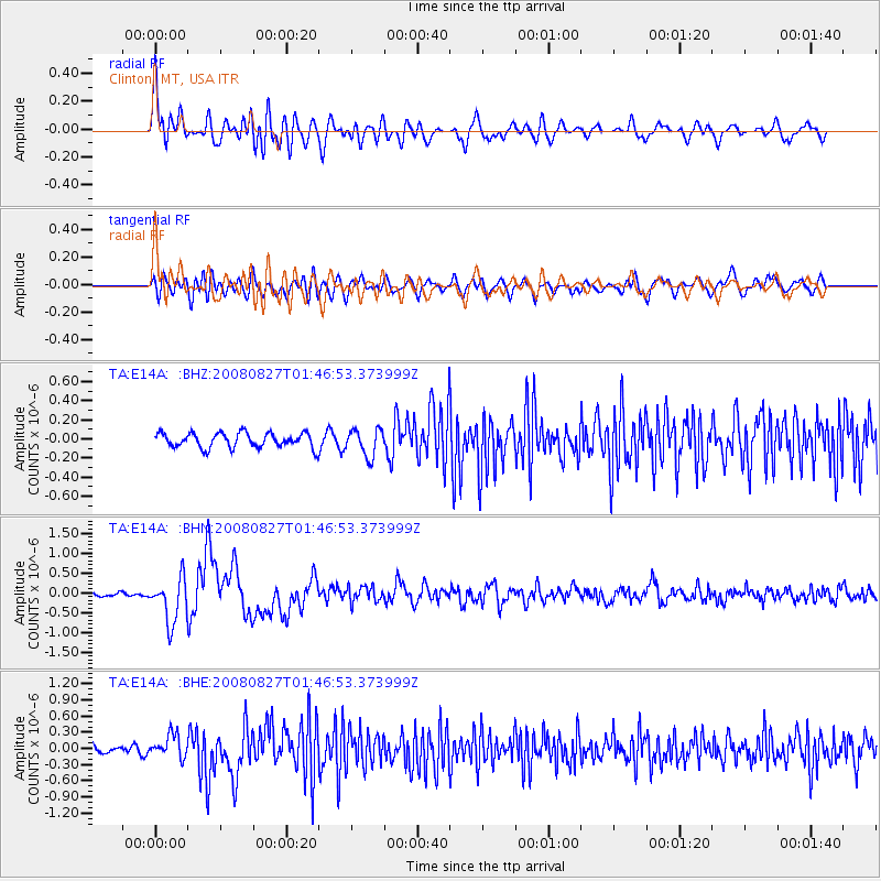
Earthquake location: Lake Baykal Region, Russia
Earthquake latitude/longitude: 51.6/104.2
Earthquake time(UTC): 2008/08/27 (240) 01:35:32 GMT
Earthquake Depth: 16 km
Earthquake Magnitude: 5.8 MB, 6.2 MS, 6.2 MW, 6.2 MW
Earthquake Catalog/Contributor: WHDF/NEIC
Network: TA USArray Transportable Network (new EarthScope stations)
Station: E14A Clinton, MT, USA
Lat/Lon: 46.42 N/113.49 W
Elevation: 1675 m
Distance: 77.1 deg
Az: 25.69 deg
Baz: 336.998 deg
Ray Param: 0.050523985
Estimated Moho Depth: 35.5 km
Estimated Crust Vp/Vs: 1.73
Assumed Crust Vp: 6.353 km/s
Estimated Crust Vs: 3.667 km/s
Estimated Crust Poisson's Ratio: 0.25
Radial Match: 86.022446 %
Radial Bump: 400
Transverse Match: 73.666016 %
Transverse Bump: 400
SOD ConfigId: 2504
Insert Time: 2010-03-06 15:41:07.813 +0000
GWidth: 2.5
Max Bumps: 400
Tol: 0.001

Signal To Noise

ChannelStoNSTALTA
TA:E14A: :BHN:20080827T01:46:53.373999Z7.9331275.603015E-77.0628076E-8
TA:E14A: :BHE:20080827T01:46:53.373999Z2.39682772.1209385E-78.848941E-8
TA:E14A: :BHZ:20080827T01:46:53.373999Z1.81817051.4043756E-77.724114E-8
Arrivals
Ps4.2 SECOND
PpPs15 SECOND
PsPs/PpSs19 SECOND