You are here: Home > Network List > AU - Australian Seismological Centre Stations List
> Station XMIS Christmas Island Grants Well > Earthquake Result Viewer
XMIS Christmas Island Grants Well - Earthquake Result Viewer
| Earthquake location: |
Kermadec Islands Region |
| Earthquake latitude/longitude: |
-31.8/-179.3 |
| Earthquake time(UTC): |
2018/09/10 (253) 04:19:02 GMT |
| Earthquake Depth: |
111 km |
| Earthquake Magnitude: |
6.9 mww |
| Earthquake Catalog/Contributor: |
NEIC PDE/us |
|
| Network: |
AU Australian Seismological Centre |
| Station: |
XMIS Christmas Island Grants Well |
| Lat/Lon: |
10.48 S/105.65 E |
| Elevation: |
210 m |
|
| Distance: |
71.9 deg |
| Az: |
268.776 deg |
| Baz: |
120.101 deg |
| Ray Param: |
0.05376705 |
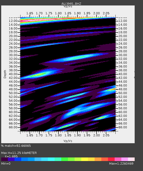
| Estimated Moho Depth: |
11.25 km |
| Estimated Crust Vp/Vs: |
1.70 |
| Assumed Crust Vp: |
4.157 km/s |
| Estimated Crust Vs: |
2.452 km/s |
| Estimated Crust Poisson's Ratio: |
0.23 |
|
| Radial Match: |
92.66865 % |
| Radial Bump: |
389 |
| Transverse Match: |
77.818886 % |
| Transverse Bump: |
400 |
| SOD ConfigId: |
13570011 |
| Insert Time: |
2019-05-01 05:07:02.756 +0000 |
| GWidth: |
2.5 |
| Max Bumps: |
400 |
| Tol: |
0.001 |
|

Signal To Noise
| Channel | StoN | STA | LTA |
| AU:XMIS: :BHZ:20180910T04:29:41.969011Z | 14.4426565 | 7.1793334E-6 | 4.970923E-7 |
| AU:XMIS: :BHN:20180910T04:29:41.969011Z | 3.5747747 | 2.7582528E-6 | 7.715879E-7 |
| AU:XMIS: :BHE:20180910T04:29:41.969011Z | 8.67499 | 4.430304E-6 | 5.1069844E-7 |
| Arrivals |
| Ps | 1.9 SECOND |
| PpPs | 7.2 SECOND |
| PsPs/PpSs | 9.1 SECOND |


