You are here: Home > Network List > TA - USArray Transportable Network (new EarthScope stations) Stations List
> Station E14A Clinton, MT, USA > Earthquake Result Viewer
E14A Clinton, MT, USA - Earthquake Result Viewer
| Earthquake location: |
Central Mid-Atlantic Ridge |
| Earthquake latitude/longitude: |
8.1/-38.7 |
| Earthquake time(UTC): |
2008/09/10 (254) 13:08:14 GMT |
| Earthquake Depth: |
10 km |
| Earthquake Magnitude: |
6.3 MB, 6.5 MS, 6.6 MW, 6.6 MW |
| Earthquake Catalog/Contributor: |
WHDF/NEIC |
|
| Network: |
TA USArray Transportable Network (new EarthScope stations) |
| Station: |
E14A Clinton, MT, USA |
| Lat/Lon: |
46.42 N/113.49 W |
| Elevation: |
1675 m |
|
| Distance: |
73.7 deg |
| Az: |
315.928 deg |
| Baz: |
95.442 deg |
| Ray Param: |
0.052837864 |
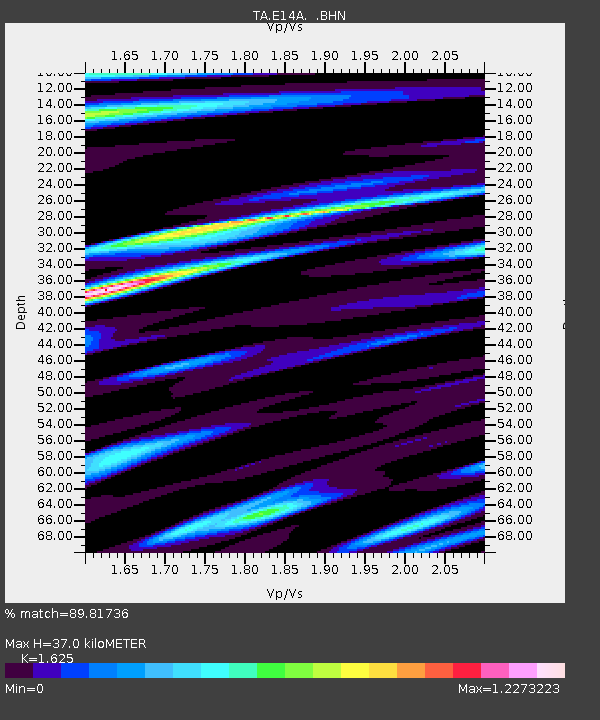
| Estimated Moho Depth: |
37.0 km |
| Estimated Crust Vp/Vs: |
1.62 |
| Assumed Crust Vp: |
6.353 km/s |
| Estimated Crust Vs: |
3.91 km/s |
| Estimated Crust Poisson's Ratio: |
0.20 |
|
| Radial Match: |
89.81736 % |
| Radial Bump: |
400 |
| Transverse Match: |
80.669624 % |
| Transverse Bump: |
400 |
| SOD ConfigId: |
2560 |
| Insert Time: |
2010-03-06 15:41:17.055 +0000 |
| GWidth: |
2.5 |
| Max Bumps: |
400 |
| Tol: |
0.001 |
|

Signal To Noise
| Channel | StoN | STA | LTA |
| TA:E14A: :BHN:20080910T13:19:17.425015Z | 3.193277 | 2.5417586E-7 | 7.9597186E-8 |
| TA:E14A: :BHE:20080910T13:19:17.425015Z | 0.85042554 | 1.0729008E-7 | 1.2616046E-7 |
| TA:E14A: :BHZ:20080910T13:19:17.425015Z | 1.4133812 | 1.3284298E-7 | 9.39895E-8 |
| Arrivals |
| Ps | 3.8 SECOND |
| PpPs | 15 SECOND |
| PsPs/PpSs | 19 SECOND |


