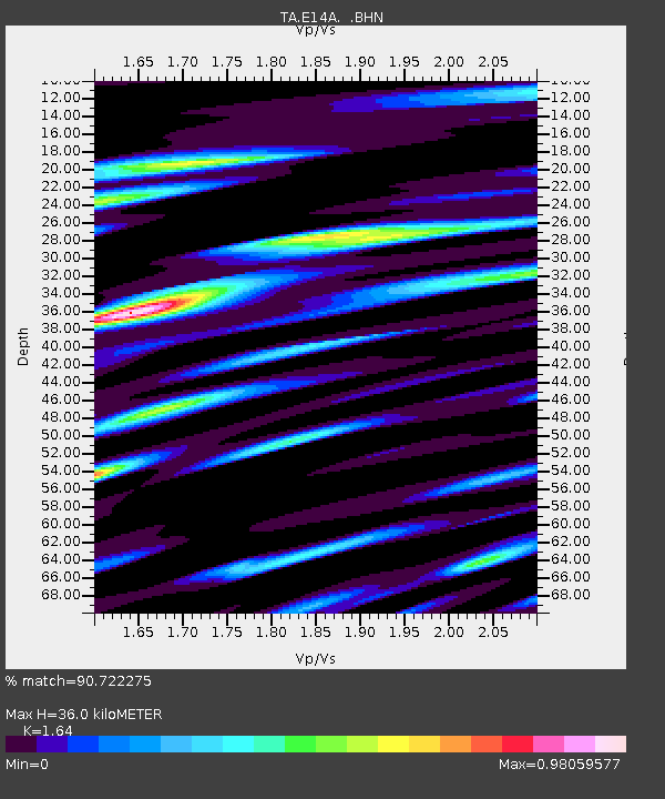
E14A Clinton, MT, USA - Earthquake Result Viewer
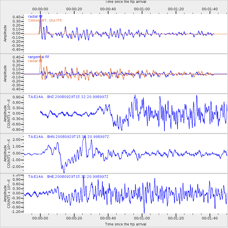
Earthquake location: Kermadec Islands, New Zealand
Earthquake latitude/longitude: -29.8/-177.7
Earthquake time(UTC): 2008/09/29 (273) 15:19:31 GMT
Earthquake Depth: 36 km
Earthquake Magnitude: 6.5 MB, 6.7 MS, 7.0 MW, 7.0 MW
Earthquake Catalog/Contributor: WHDF/NEIC
Network: TA USArray Transportable Network (new EarthScope stations)
Station: E14A Clinton, MT, USA
Lat/Lon: 46.42 N/113.49 W
Elevation: 1675 m
Distance: 95.4 deg
Az: 38.729 deg
Baz: 231.847 deg
Ray Param: 0.040768053
Estimated Moho Depth: 36.0 km
Estimated Crust Vp/Vs: 1.64
Assumed Crust Vp: 6.353 km/s
Estimated Crust Vs: 3.874 km/s
Estimated Crust Poisson's Ratio: 0.20
Radial Match: 90.722275 %
Radial Bump: 400
Transverse Match: 73.976974 %
Transverse Bump: 400
SOD ConfigId: 2560
Insert Time: 2010-03-06 15:41:18.853 +0000
GWidth: 2.5
Max Bumps: 400
Tol: 0.001

Signal To Noise

ChannelStoNSTALTA
TA:E14A: :BHN:20080929T15:32:20.998997Z4.62804755.297159E-71.14457755E-7
TA:E14A: :BHE:20080929T15:32:20.998997Z0.78358587.928542E-81.0118282E-7
TA:E14A: :BHZ:20080929T15:32:20.998997Z1.87771311.5086333E-78.034418E-8
Arrivals
Ps3.7 SECOND
PpPs15 SECOND
PsPs/PpSs18 SECOND