You are here: Home > Network List > AV - Alaska Volcano Observatory Stations List
> Station MAPS Pakushin Southeast, Makushin Volcano, Alaska > Earthquake Result Viewer
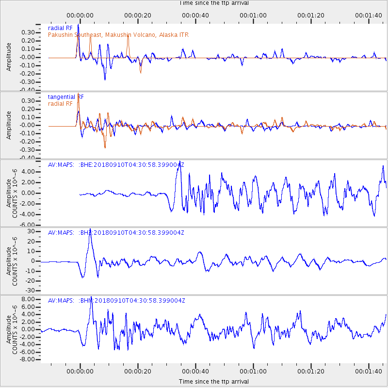
MAPS Pakushin Southeast, Makushin Volcano, Alaska - Earthquake Result Viewer
| Earthquake location: |
Kermadec Islands Region |
| Earthquake latitude/longitude: |
-31.8/-179.3 |
| Earthquake time(UTC): |
2018/09/10 (253) 04:19:02 GMT |
| Earthquake Depth: |
111 km |
| Earthquake Magnitude: |
6.9 mww |
| Earthquake Catalog/Contributor: |
NEIC PDE/us |
|
| Network: |
AV Alaska Volcano Observatory |
| Station: |
MAPS Pakushin Southeast, Makushin Volcano, Alaska |
| Lat/Lon: |
53.81 N/166.94 W |
| Elevation: |
333 m |
|
| Distance: |
86.0 deg |
| Az: |
7.331 deg |
| Baz: |
190.551 deg |
| Ray Param: |
0.044149082 |
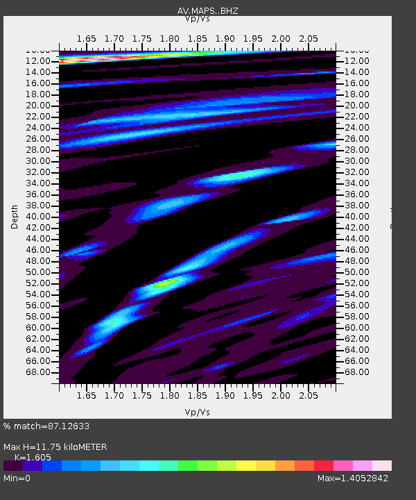
| Estimated Moho Depth: |
11.75 km |
| Estimated Crust Vp/Vs: |
1.61 |
| Assumed Crust Vp: |
3.943 km/s |
| Estimated Crust Vs: |
2.457 km/s |
| Estimated Crust Poisson's Ratio: |
0.18 |
|
| Radial Match: |
87.12633 % |
| Radial Bump: |
400 |
| Transverse Match: |
88.59797 % |
| Transverse Bump: |
400 |
| SOD ConfigId: |
13570011 |
| Insert Time: |
2019-05-01 05:07:21.807 +0000 |
| GWidth: |
2.5 |
| Max Bumps: |
400 |
| Tol: |
0.001 |
|
Signal To Noise
| Channel | StoN | STA | LTA |
| AV:MAPS: :BHZ:20180910T04:30:58.399004Z | 91.64724 | 1.5242326E-5 | 1.6631517E-7 |
| AV:MAPS: :BHN:20180910T04:30:58.399004Z | 16.097576 | 3.844728E-6 | 2.388389E-7 |
| AV:MAPS: :BHE:20180910T04:30:58.399004Z | 12.202268 | 3.1372392E-6 | 2.5710295E-7 |
| Arrivals |
| Ps | 1.8 SECOND |
| PpPs | 7.7 SECOND |
| PsPs/PpSs | 9.5 SECOND |


