You are here: Home > Network List > TA - USArray Transportable Network (new EarthScope stations) Stations List
> Station E14A Clinton, MT, USA > Earthquake Result Viewer
E14A Clinton, MT, USA - Earthquake Result Viewer
| Earthquake location: |
North Of Honduras |
| Earthquake latitude/longitude: |
16.7/-86.2 |
| Earthquake time(UTC): |
2009/05/28 (148) 08:24:45 GMT |
| Earthquake Depth: |
10 km |
| Earthquake Magnitude: |
6.7 MB, 7.2 MS, 7.3 MW, 7.3 MW |
| Earthquake Catalog/Contributor: |
WHDF/NEIC |
|
| Network: |
TA USArray Transportable Network (new EarthScope stations) |
| Station: |
E14A Clinton, MT, USA |
| Lat/Lon: |
46.42 N/113.49 W |
| Elevation: |
1675 m |
|
| Distance: |
37.3 deg |
| Az: |
328.449 deg |
| Baz: |
133.551 deg |
| Ray Param: |
0.076227024 |
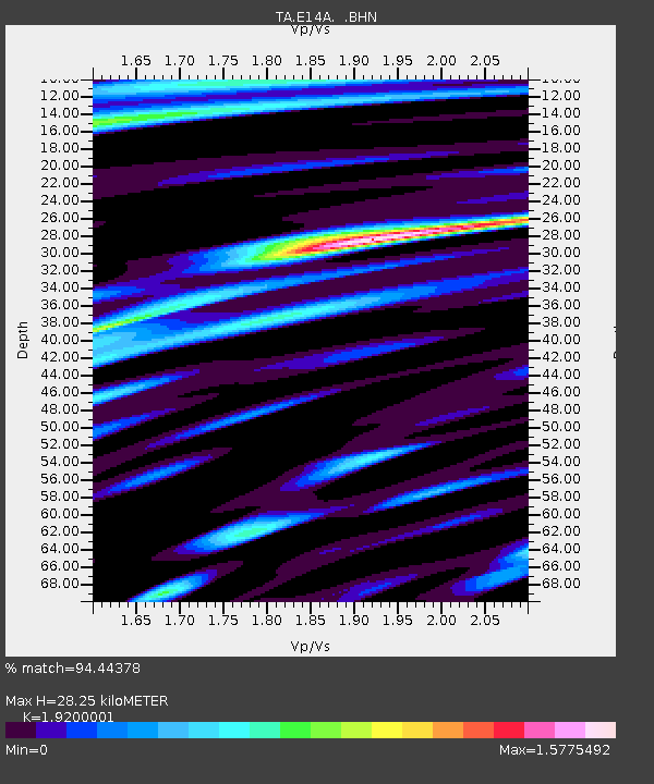
| Estimated Moho Depth: |
28.25 km |
| Estimated Crust Vp/Vs: |
1.92 |
| Assumed Crust Vp: |
6.353 km/s |
| Estimated Crust Vs: |
3.309 km/s |
| Estimated Crust Poisson's Ratio: |
0.31 |
|
| Radial Match: |
94.44378 % |
| Radial Bump: |
400 |
| Transverse Match: |
81.63106 % |
| Transverse Bump: |
400 |
| SOD ConfigId: |
2648 |
| Insert Time: |
2010-03-06 15:41:24.891 +0000 |
| GWidth: |
2.5 |
| Max Bumps: |
400 |
| Tol: |
0.001 |
|
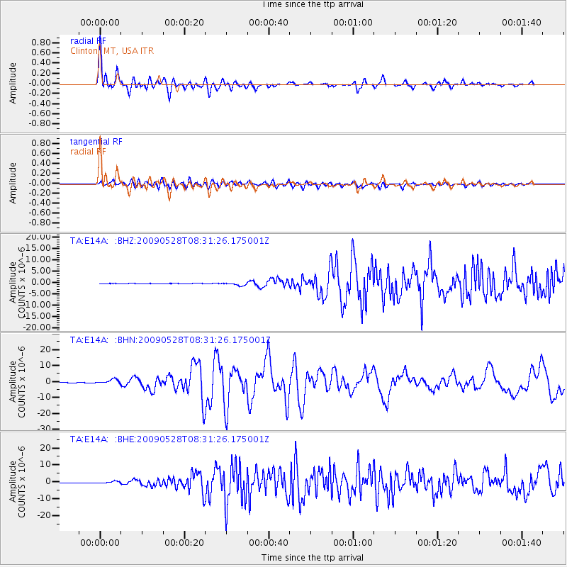
Signal To Noise
| Channel | StoN | STA | LTA |
| TA:E14A: :BHN:20090528T08:31:26.175001Z | 18.450956 | 1.408455E-6 | 7.633506E-8 |
| TA:E14A: :BHE:20090528T08:31:26.175001Z | 7.4330173 | 5.677801E-7 | 7.638622E-8 |
| TA:E14A: :BHZ:20090528T08:31:26.175001Z | 11.656247 | 6.206574E-7 | 5.3246758E-8 |
| Arrivals |
| Ps | 4.4 SECOND |
| PpPs | 12 SECOND |
| PsPs/PpSs | 17 SECOND |


