You are here: Home > Network List > AV - Alaska Volcano Observatory Stations List
> Station PLBL Mt. Peulik Volcano, Alaska > Earthquake Result Viewer
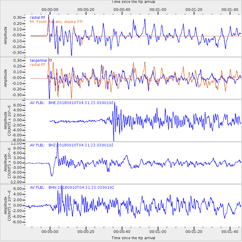
PLBL Mt. Peulik Volcano, Alaska - Earthquake Result Viewer
*The percent match for this event was below the threshold and hence no stack was calculated.
| Earthquake location: |
Kermadec Islands Region |
| Earthquake latitude/longitude: |
-31.8/-179.3 |
| Earthquake time(UTC): |
2018/09/10 (253) 04:19:02 GMT |
| Earthquake Depth: |
111 km |
| Earthquake Magnitude: |
6.9 mww |
| Earthquake Catalog/Contributor: |
NEIC PDE/us |
|
| Network: |
AV Alaska Volcano Observatory |
| Station: |
PLBL Mt. Peulik Volcano, Alaska |
| Lat/Lon: |
57.70 N/156.82 W |
| Elevation: |
461 m |
|
| Distance: |
91.2 deg |
| Az: |
11.866 deg |
| Baz: |
199.023 deg |
| Ray Param: |
$rayparam |
*The percent match for this event was below the threshold and hence was not used in the summary stack. |
|
| Radial Match: |
78.66487 % |
| Radial Bump: |
400 |
| Transverse Match: |
82.906944 % |
| Transverse Bump: |
400 |
| SOD ConfigId: |
13570011 |
| Insert Time: |
2019-05-01 05:07:28.076 +0000 |
| GWidth: |
2.5 |
| Max Bumps: |
400 |
| Tol: |
0.001 |
|
Signal To Noise
| Channel | StoN | STA | LTA |
| AV:PLBL: :BHZ:20180910T04:31:23.039019Z | 35.28928 | 5.348394E-6 | 1.5155861E-7 |
| AV:PLBL: :BHN:20180910T04:31:23.039019Z | 4.0200677 | 1.6422604E-6 | 4.0851563E-7 |
| AV:PLBL: :BHE:20180910T04:31:23.039019Z | 8.624062 | 2.041238E-6 | 2.3669105E-7 |
| Arrivals |
| Ps | |
| PpPs | |
| PsPs/PpSs | |


