You are here: Home > Network List > AV - Alaska Volcano Observatory Stations List
> Station STLK Strandline Lake, Regional Station, Alaska > Earthquake Result Viewer
STLK Strandline Lake, Regional Station, Alaska - Earthquake Result Viewer
| Earthquake location: |
Kermadec Islands Region |
| Earthquake latitude/longitude: |
-31.8/-179.3 |
| Earthquake time(UTC): |
2018/09/10 (253) 04:19:02 GMT |
| Earthquake Depth: |
111 km |
| Earthquake Magnitude: |
6.9 mww |
| Earthquake Catalog/Contributor: |
NEIC PDE/us |
|
| Network: |
AV Alaska Volcano Observatory |
| Station: |
STLK Strandline Lake, Regional Station, Alaska |
| Lat/Lon: |
61.50 N/151.83 W |
| Elevation: |
945 m |
|
| Distance: |
95.7 deg |
| Az: |
12.859 deg |
| Baz: |
203.259 deg |
| Ray Param: |
0.04064417 |
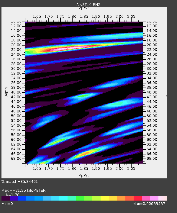
| Estimated Moho Depth: |
21.25 km |
| Estimated Crust Vp/Vs: |
1.78 |
| Assumed Crust Vp: |
6.302 km/s |
| Estimated Crust Vs: |
3.54 km/s |
| Estimated Crust Poisson's Ratio: |
0.27 |
|
| Radial Match: |
85.84461 % |
| Radial Bump: |
400 |
| Transverse Match: |
81.38374 % |
| Transverse Bump: |
400 |
| SOD ConfigId: |
13570011 |
| Insert Time: |
2019-05-01 05:07:46.550 +0000 |
| GWidth: |
2.5 |
| Max Bumps: |
400 |
| Tol: |
0.001 |
|
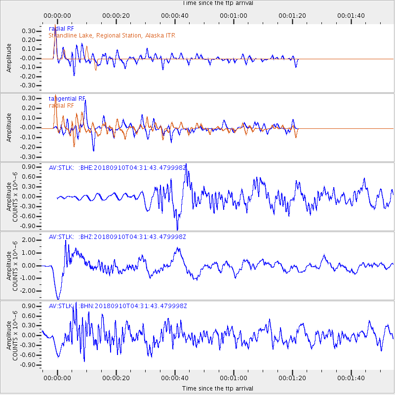
Signal To Noise
| Channel | StoN | STA | LTA |
| AV:STLK: :BHZ:20180910T04:31:43.479998Z | 27.35036 | 1.5765916E-6 | 5.7644268E-8 |
| AV:STLK: :BHN:20180910T04:31:43.479998Z | 5.2405853 | 3.5329882E-7 | 6.7415904E-8 |
| AV:STLK: :BHE:20180910T04:31:43.479998Z | 4.3596916 | 2.6478523E-7 | 6.0734855E-8 |
| Arrivals |
| Ps | 2.7 SECOND |
| PpPs | 9.2 SECOND |
| PsPs/PpSs | 12 SECOND |


