You are here: Home > Network List > TA - USArray Transportable Network (new EarthScope stations) Stations List
> Station E14A Clinton, MT, USA > Earthquake Result Viewer
E14A Clinton, MT, USA - Earthquake Result Viewer
| Earthquake location: |
East Of Kuril Islands |
| Earthquake latitude/longitude: |
46.7/155.3 |
| Earthquake time(UTC): |
2006/11/15 (319) 11:34:58 GMT |
| Earthquake Depth: |
10 km |
| Earthquake Magnitude: |
6.4 MB |
| Earthquake Catalog/Contributor: |
WHDF/NEIC |
|
| Network: |
TA USArray Transportable Network (new EarthScope stations) |
| Station: |
E14A Clinton, MT, USA |
| Lat/Lon: |
46.42 N/113.49 W |
| Elevation: |
1675 m |
|
| Distance: |
59.1 deg |
| Az: |
53.71 deg |
| Baz: |
306.625 deg |
| Ray Param: |
0.06240618 |
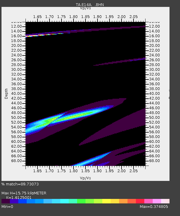
| Estimated Moho Depth: |
15.75 km |
| Estimated Crust Vp/Vs: |
1.61 |
| Assumed Crust Vp: |
6.353 km/s |
| Estimated Crust Vs: |
3.94 km/s |
| Estimated Crust Poisson's Ratio: |
0.19 |
|
| Radial Match: |
89.73073 % |
| Radial Bump: |
354 |
| Transverse Match: |
36.82187 % |
| Transverse Bump: |
230 |
| SOD ConfigId: |
2564 |
| Insert Time: |
2010-03-06 15:41:38.683 +0000 |
| GWidth: |
2.5 |
| Max Bumps: |
400 |
| Tol: |
0.001 |
|
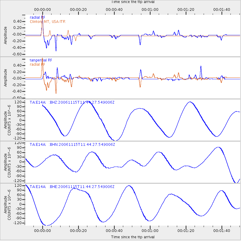
Signal To Noise
| Channel | StoN | STA | LTA |
| TA:E14A: :BHN:20061115T11:44:27.549006Z | 1.1794351 | 3.0263172E-5 | 2.565904E-5 |
| TA:E14A: :BHE:20061115T11:44:27.549006Z | 1.420632 | 1.448807E-4 | 1.0198328E-4 |
| TA:E14A: :BHZ:20061115T11:44:27.549006Z | 0.4985058 | 3.689789E-5 | 7.401698E-5 |
| Arrivals |
| Ps | 1.6 SECOND |
| PpPs | 6.2 SECOND |
| PsPs/PpSs | 7.7 SECOND |


