You are here: Home > Network List > C - Chilean National Seismic Network Stations List
> Station LMEL LMEL > Earthquake Result Viewer
LMEL LMEL - Earthquake Result Viewer
| Earthquake location: |
Kermadec Islands Region |
| Earthquake latitude/longitude: |
-31.8/-179.3 |
| Earthquake time(UTC): |
2018/09/10 (253) 04:19:02 GMT |
| Earthquake Depth: |
111 km |
| Earthquake Magnitude: |
6.9 mww |
| Earthquake Catalog/Contributor: |
NEIC PDE/us |
|
| Network: |
C Chilean National Seismic Network |
| Station: |
LMEL LMEL |
| Lat/Lon: |
33.85 S/70.21 W |
| Elevation: |
1536 m |
|
| Distance: |
86.6 deg |
| Az: |
128.031 deg |
| Baz: |
233.66 deg |
| Ray Param: |
0.04368172 |
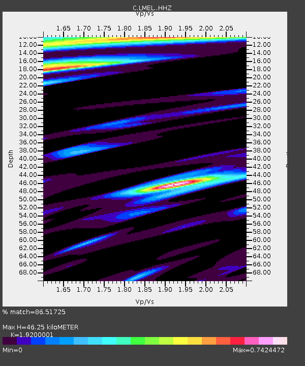
| Estimated Moho Depth: |
46.25 km |
| Estimated Crust Vp/Vs: |
1.92 |
| Assumed Crust Vp: |
6.481 km/s |
| Estimated Crust Vs: |
3.375 km/s |
| Estimated Crust Poisson's Ratio: |
0.31 |
|
| Radial Match: |
86.51725 % |
| Radial Bump: |
400 |
| Transverse Match: |
77.37661 % |
| Transverse Bump: |
400 |
| SOD ConfigId: |
13570011 |
| Insert Time: |
2019-05-01 05:08:22.098 +0000 |
| GWidth: |
2.5 |
| Max Bumps: |
400 |
| Tol: |
0.001 |
|

Signal To Noise
| Channel | StoN | STA | LTA |
| C:LMEL: :HHZ:20180910T04:31:02.407976Z | 8.809829 | 5.6050726E-6 | 6.3622946E-7 |
| C:LMEL: :HHN:20180910T04:31:02.407976Z | 2.682779 | 1.2229981E-6 | 4.5586984E-7 |
| C:LMEL: :HHE:20180910T04:31:02.407976Z | 3.836983 | 1.2142928E-6 | 3.164707E-7 |
| Arrivals |
| Ps | 6.7 SECOND |
| PpPs | 20 SECOND |
| PsPs/PpSs | 27 SECOND |


