You are here: Home > Network List > TA - USArray Transportable Network (new EarthScope stations) Stations List
> Station E14A Clinton, MT, USA > Earthquake Result Viewer
E14A Clinton, MT, USA - Earthquake Result Viewer
| Earthquake location: |
Andreanof Islands, Aleutian Is. |
| Earthquake latitude/longitude: |
51.4/-179.0 |
| Earthquake time(UTC): |
2007/12/21 (355) 07:24:34 GMT |
| Earthquake Depth: |
30 km |
| Earthquake Magnitude: |
6.1 MB, 6.2 MW, 6.3 ML |
| Earthquake Catalog/Contributor: |
WHDF/NEIC |
|
| Network: |
TA USArray Transportable Network (new EarthScope stations) |
| Station: |
E14A Clinton, MT, USA |
| Lat/Lon: |
46.42 N/113.49 W |
| Elevation: |
1675 m |
|
| Distance: |
42.1 deg |
| Az: |
70.002 deg |
| Baz: |
301.611 deg |
| Ray Param: |
0.07334173 |
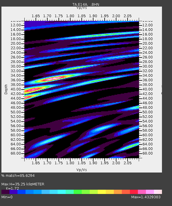
| Estimated Moho Depth: |
35.25 km |
| Estimated Crust Vp/Vs: |
1.72 |
| Assumed Crust Vp: |
6.353 km/s |
| Estimated Crust Vs: |
3.694 km/s |
| Estimated Crust Poisson's Ratio: |
0.24 |
|
| Radial Match: |
85.6294 % |
| Radial Bump: |
400 |
| Transverse Match: |
66.88705 % |
| Transverse Bump: |
400 |
| SOD ConfigId: |
2564 |
| Insert Time: |
2010-03-06 15:41:48.083 +0000 |
| GWidth: |
2.5 |
| Max Bumps: |
400 |
| Tol: |
0.001 |
|
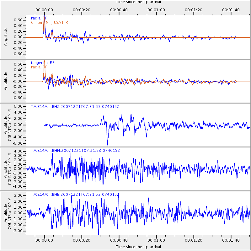
Signal To Noise
| Channel | StoN | STA | LTA |
| TA:E14A: :BHN:20071221T07:31:53.074015Z | 2.3965933 | 1.1260893E-6 | 4.698708E-7 |
| TA:E14A: :BHE:20071221T07:31:53.074015Z | 2.6501977 | 1.0972359E-6 | 4.1402035E-7 |
| TA:E14A: :BHZ:20071221T07:31:53.074015Z | 10.0346575 | 2.2489346E-6 | 2.2411673E-7 |
| Arrivals |
| Ps | 4.3 SECOND |
| PpPs | 14 SECOND |
| PsPs/PpSs | 18 SECOND |


