You are here: Home > Network List > C1 - Red Sismologica Nacional Stations List
> Station LR05 Currine > Earthquake Result Viewer
LR05 Currine - Earthquake Result Viewer
| Earthquake location: |
Kermadec Islands Region |
| Earthquake latitude/longitude: |
-31.8/-179.3 |
| Earthquake time(UTC): |
2018/09/10 (253) 04:19:02 GMT |
| Earthquake Depth: |
111 km |
| Earthquake Magnitude: |
6.9 mww |
| Earthquake Catalog/Contributor: |
NEIC PDE/us |
|
| Network: |
C1 Red Sismologica Nacional |
| Station: |
LR05 Currine |
| Lat/Lon: |
40.23 S/72.00 W |
| Elevation: |
204 m |
|
| Distance: |
81.7 deg |
| Az: |
132.396 deg |
| Baz: |
235.183 deg |
| Ray Param: |
0.04712431 |
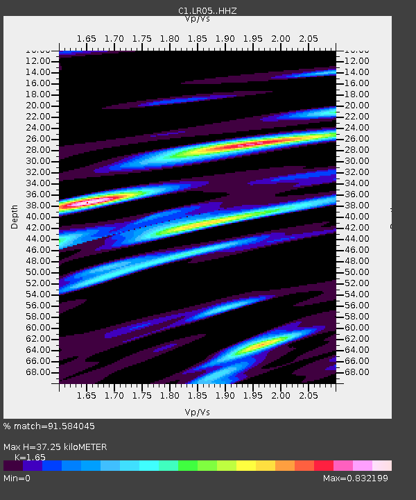
| Estimated Moho Depth: |
37.25 km |
| Estimated Crust Vp/Vs: |
1.65 |
| Assumed Crust Vp: |
6.522 km/s |
| Estimated Crust Vs: |
3.952 km/s |
| Estimated Crust Poisson's Ratio: |
0.21 |
|
| Radial Match: |
91.584045 % |
| Radial Bump: |
321 |
| Transverse Match: |
81.2681 % |
| Transverse Bump: |
352 |
| SOD ConfigId: |
13570011 |
| Insert Time: |
2019-05-01 05:08:43.797 +0000 |
| GWidth: |
2.5 |
| Max Bumps: |
400 |
| Tol: |
0.001 |
|

Signal To Noise
| Channel | StoN | STA | LTA |
| C1:LR05: :HHZ:20180910T04:30:37.889971Z | 32.125114 | 1.0610111E-5 | 3.3027464E-7 |
| C1:LR05: :HHN:20180910T04:30:37.889971Z | 6.781935 | 2.9685807E-6 | 4.3771882E-7 |
| C1:LR05: :HHE:20180910T04:30:37.889971Z | 5.9095583 | 4.892138E-6 | 8.2783475E-7 |
| Arrivals |
| Ps | 3.8 SECOND |
| PpPs | 15 SECOND |
| PsPs/PpSs | 19 SECOND |


