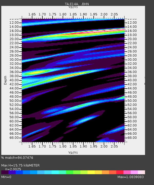
E14A Clinton, MT, USA - Earthquake Result Viewer
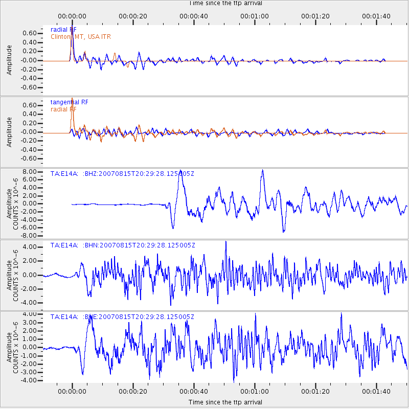
Earthquake location: Andreanof Islands, Aleutian Is.
Earthquake latitude/longitude: 50.3/-177.5
Earthquake time(UTC): 2007/08/15 (227) 20:22:11 GMT
Earthquake Depth: 9.0 km
Earthquake Magnitude: 6.3 MB, 6.2 MS, 6.4 MW, 5.9 ML
Earthquake Catalog/Contributor: WHDF/NEIC
Network: TA USArray Transportable Network (new EarthScope stations)
Station: E14A Clinton, MT, USA
Lat/Lon: 46.42 N/113.49 W
Elevation: 1675 m
Distance: 41.6 deg
Az: 69.668 deg
Baz: 299.68 deg
Ray Param: 0.073715635
Estimated Moho Depth: 15.75 km
Estimated Crust Vp/Vs: 2.00
Assumed Crust Vp: 6.353 km/s
Estimated Crust Vs: 3.173 km/s
Estimated Crust Poisson's Ratio: 0.33
Radial Match: 94.07476 %
Radial Bump: 400
Transverse Match: 78.076126 %
Transverse Bump: 400
SOD ConfigId: 2564
Insert Time: 2010-03-06 15:42:20.573 +0000
GWidth: 2.5
Max Bumps: 400
Tol: 0.001

Signal To Noise

ChannelStoNSTALTA
TA:E14A: :BHN:20070815T20:29:28.125005Z4.4403687.82484E-71.7622051E-7
TA:E14A: :BHE:20070815T20:29:28.125005Z12.579161.2383387E-69.844368E-8
TA:E14A: :BHZ:20070815T20:29:28.125005Z28.9861532.4809633E-68.559133E-8
Arrivals
Ps2.6 SECOND
PpPs7.0 SECOND
PsPs/PpSs9.7 SECOND