You are here: Home > Network List > CI - Caltech Regional Seismic Network Stations List
> Station SWS Sam W. Stewart, Westmorland, CA, USA > Earthquake Result Viewer
SWS Sam W. Stewart, Westmorland, CA, USA - Earthquake Result Viewer
| Earthquake location: |
Kermadec Islands Region |
| Earthquake latitude/longitude: |
-31.8/-179.3 |
| Earthquake time(UTC): |
2018/09/10 (253) 04:19:02 GMT |
| Earthquake Depth: |
111 km |
| Earthquake Magnitude: |
6.9 mww |
| Earthquake Catalog/Contributor: |
NEIC PDE/us |
|
| Network: |
CI Caltech Regional Seismic Network |
| Station: |
SWS Sam W. Stewart, Westmorland, CA, USA |
| Lat/Lon: |
32.94 N/115.80 W |
| Elevation: |
140 m |
|
| Distance: |
88.0 deg |
| Az: |
48.872 deg |
| Baz: |
229.674 deg |
| Ray Param: |
0.042669836 |
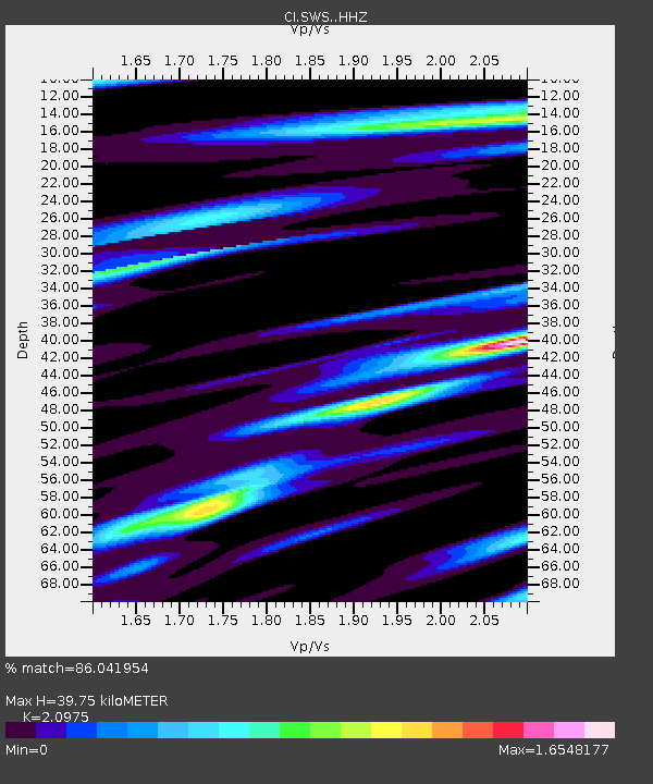
| Estimated Moho Depth: |
39.75 km |
| Estimated Crust Vp/Vs: |
2.10 |
| Assumed Crust Vp: |
6.155 km/s |
| Estimated Crust Vs: |
2.934 km/s |
| Estimated Crust Poisson's Ratio: |
0.35 |
|
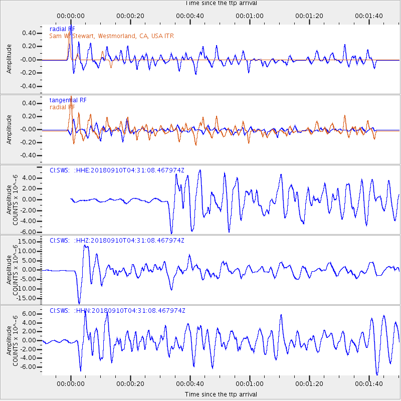
| Radial Match: |
86.041954 % |
| Radial Bump: |
400 |
| Transverse Match: |
85.78987 % |
| Transverse Bump: |
400 |
| SOD ConfigId: |
13570011 |
| Insert Time: |
2019-05-01 05:10:11.774 +0000 |
| GWidth: |
2.5 |
| Max Bumps: |
400 |
| Tol: |
0.001 |
|
Signal To Noise
| Channel | StoN | STA | LTA |
| CI:SWS: :HHZ:20180910T04:31:08.467974Z | 49.06216 | 8.281799E-6 | 1.6880216E-7 |
| CI:SWS: :HHN:20180910T04:31:08.467974Z | 10.032184 | 2.6669745E-6 | 2.6584186E-7 |
| CI:SWS: :HHE:20180910T04:31:08.467974Z | 10.914845 | 2.4426618E-6 | 2.2379261E-7 |
| Arrivals |
| Ps | 7.2 SECOND |
| PpPs | 20 SECOND |
| PsPs/PpSs | 27 SECOND |


