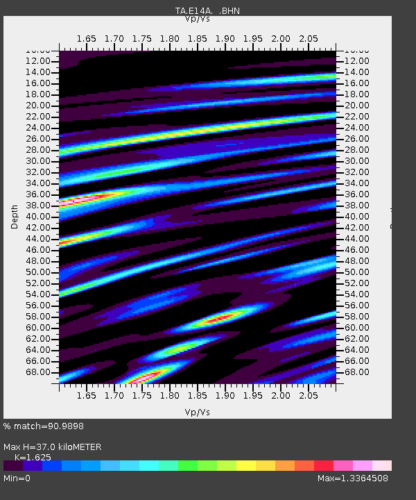
E14A Clinton, MT, USA - Earthquake Result Viewer
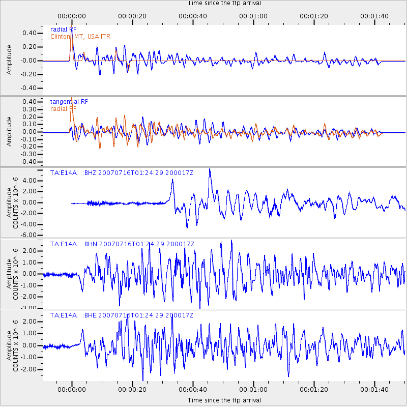
Earthquake location: Near West Coast Of Honshu, Japan
Earthquake latitude/longitude: 37.5/138.4
Earthquake time(UTC): 2007/07/16 (197) 01:13:22 GMT
Earthquake Depth: 12 km
Earthquake Magnitude: 6.5 MB, 6.4 MS, 6.6 MW, 6.5 MW
Earthquake Catalog/Contributor: WHDF/NEIC
Network: TA USArray Transportable Network (new EarthScope stations)
Station: E14A Clinton, MT, USA
Lat/Lon: 46.42 N/113.49 W
Elevation: 1675 m
Distance: 74.5 deg
Az: 43.05 deg
Baz: 308.337 deg
Ray Param: 0.05229975
Estimated Moho Depth: 37.0 km
Estimated Crust Vp/Vs: 1.62
Assumed Crust Vp: 6.353 km/s
Estimated Crust Vs: 3.91 km/s
Estimated Crust Poisson's Ratio: 0.20
Radial Match: 90.9898 %
Radial Bump: 400
Transverse Match: 86.62387 %
Transverse Bump: 400
SOD ConfigId: 2564
Insert Time: 2010-03-06 15:42:35.766 +0000
GWidth: 2.5
Max Bumps: 400
Tol: 0.001

Signal To Noise

ChannelStoNSTALTA
TA:E14A: :BHN:20070716T01:24:29.200017Z4.42935284.994846E-71.12766955E-7
TA:E14A: :BHE:20070716T01:24:29.200017Z4.9796645.043714E-71.0128624E-7
TA:E14A: :BHZ:20070716T01:24:29.200017Z13.0582481.5818719E-61.2113968E-7
Arrivals
Ps3.8 SECOND
PpPs15 SECOND
PsPs/PpSs19 SECOND