You are here: Home > Network List > IE - INL Seismic Monitoring Program Stations List
> Station COMI Craters of the Moon, Idaho, USA > Earthquake Result Viewer
COMI Craters of the Moon, Idaho, USA - Earthquake Result Viewer
| Earthquake location: |
Kermadec Islands Region |
| Earthquake latitude/longitude: |
-31.8/-179.3 |
| Earthquake time(UTC): |
2018/09/10 (253) 04:19:02 GMT |
| Earthquake Depth: |
111 km |
| Earthquake Magnitude: |
6.9 mww |
| Earthquake Catalog/Contributor: |
NEIC PDE/us |
|
| Network: |
IE INL Seismic Monitoring Program |
| Station: |
COMI Craters of the Moon, Idaho, USA |
| Lat/Lon: |
43.46 N/113.59 W |
| Elevation: |
1890 m |
|
| Distance: |
96.0 deg |
| Az: |
41.877 deg |
| Baz: |
231.284 deg |
| Ray Param: |
0.040542312 |
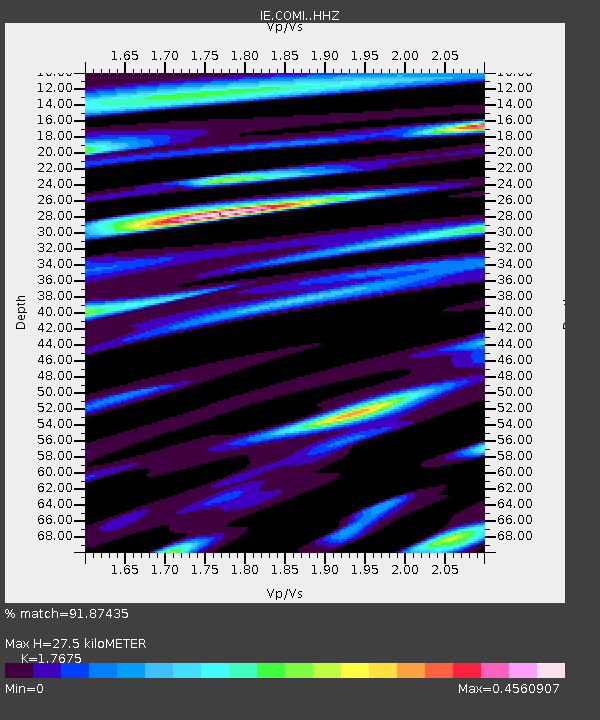
| Estimated Moho Depth: |
27.5 km |
| Estimated Crust Vp/Vs: |
1.77 |
| Assumed Crust Vp: |
6.279 km/s |
| Estimated Crust Vs: |
3.552 km/s |
| Estimated Crust Poisson's Ratio: |
0.26 |
|
| Radial Match: |
91.87435 % |
| Radial Bump: |
350 |
| Transverse Match: |
87.31082 % |
| Transverse Bump: |
400 |
| SOD ConfigId: |
13570011 |
| Insert Time: |
2019-05-01 05:10:56.181 +0000 |
| GWidth: |
2.5 |
| Max Bumps: |
400 |
| Tol: |
0.001 |
|

Signal To Noise
| Channel | StoN | STA | LTA |
| IE:COMI: :HHZ:20180910T04:31:45.367998Z | 32.761265 | 2.363183E-6 | 7.2133446E-8 |
| IE:COMI: :HHN:20180910T04:31:45.367998Z | 10.84287 | 7.964474E-7 | 7.345356E-8 |
| IE:COMI: :HHE:20180910T04:31:45.367998Z | 5.7035556 | 4.6075803E-7 | 8.078435E-8 |
| Arrivals |
| Ps | 3.4 SECOND |
| PpPs | 12 SECOND |
| PsPs/PpSs | 15 SECOND |


