You are here: Home > Network List > TA - USArray Transportable Network (new EarthScope stations) Stations List
> Station E14A Clinton, MT, USA > Earthquake Result Viewer
E14A Clinton, MT, USA - Earthquake Result Viewer
| Earthquake location: |
Loyalty Islands |
| Earthquake latitude/longitude: |
-20.1/168.9 |
| Earthquake time(UTC): |
2008/04/09 (100) 12:46:12 GMT |
| Earthquake Depth: |
33 km |
| Earthquake Magnitude: |
6.3 MB, 7.3 MS, 7.3 MW, 7.3 MW |
| Earthquake Catalog/Contributor: |
WHDF/NEIC |
|
| Network: |
TA USArray Transportable Network (new EarthScope stations) |
| Station: |
E14A Clinton, MT, USA |
| Lat/Lon: |
46.42 N/113.49 W |
| Elevation: |
1675 m |
|
| Distance: |
96.1 deg |
| Az: |
42.815 deg |
| Baz: |
247.431 deg |
| Ray Param: |
0.040583163 |
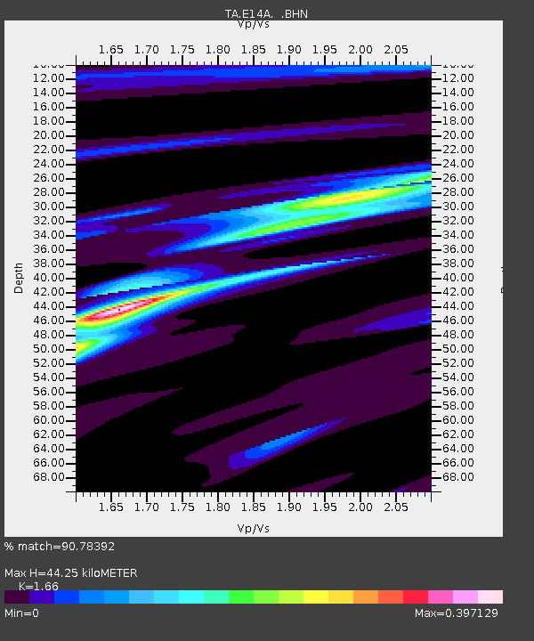
| Estimated Moho Depth: |
44.25 km |
| Estimated Crust Vp/Vs: |
1.66 |
| Assumed Crust Vp: |
6.353 km/s |
| Estimated Crust Vs: |
3.827 km/s |
| Estimated Crust Poisson's Ratio: |
0.22 |
|
| Radial Match: |
90.78392 % |
| Radial Bump: |
249 |
| Transverse Match: |
85.56171 % |
| Transverse Bump: |
306 |
| SOD ConfigId: |
2504 |
| Insert Time: |
2010-03-06 15:42:56.415 +0000 |
| GWidth: |
2.5 |
| Max Bumps: |
400 |
| Tol: |
0.001 |
|

Signal To Noise
| Channel | StoN | STA | LTA |
| TA:E14A: :BHN:20080409T12:59:05.675017Z | 14.823316 | 1.706852E-6 | 1.15146435E-7 |
| TA:E14A: :BHE:20080409T12:59:05.675017Z | 1.2128919 | 3.305365E-7 | 2.7251934E-7 |
| TA:E14A: :BHZ:20080409T12:59:05.675017Z | 1.7541496 | 3.3139767E-7 | 1.8892213E-7 |
| Arrivals |
| Ps | 4.7 SECOND |
| PpPs | 18 SECOND |
| PsPs/PpSs | 23 SECOND |


