You are here: Home > Network List > PS - Pacific21 Stations List
> Station PSI Parapat, Indonesia > Earthquake Result Viewer
PSI Parapat, Indonesia - Earthquake Result Viewer
| Earthquake location: |
Kermadec Islands Region |
| Earthquake latitude/longitude: |
-31.8/-179.3 |
| Earthquake time(UTC): |
2018/09/10 (253) 04:19:02 GMT |
| Earthquake Depth: |
111 km |
| Earthquake Magnitude: |
6.9 mww |
| Earthquake Catalog/Contributor: |
NEIC PDE/us |
|
| Network: |
PS Pacific21 |
| Station: |
PSI Parapat, Indonesia |
| Lat/Lon: |
2.69 N/98.92 E |
| Elevation: |
987 m |
|
| Distance: |
84.4 deg |
| Az: |
276.638 deg |
| Baz: |
122.188 deg |
| Ray Param: |
0.045265764 |
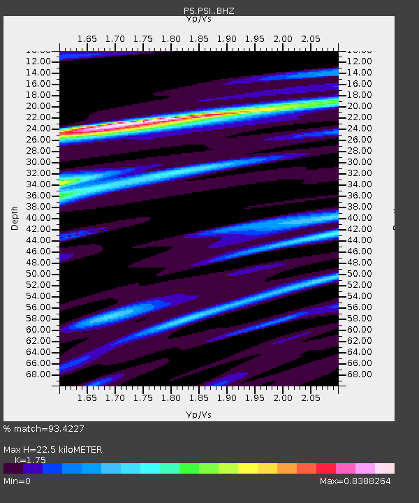
| Estimated Moho Depth: |
22.5 km |
| Estimated Crust Vp/Vs: |
1.75 |
| Assumed Crust Vp: |
6.468 km/s |
| Estimated Crust Vs: |
3.696 km/s |
| Estimated Crust Poisson's Ratio: |
0.26 |
|
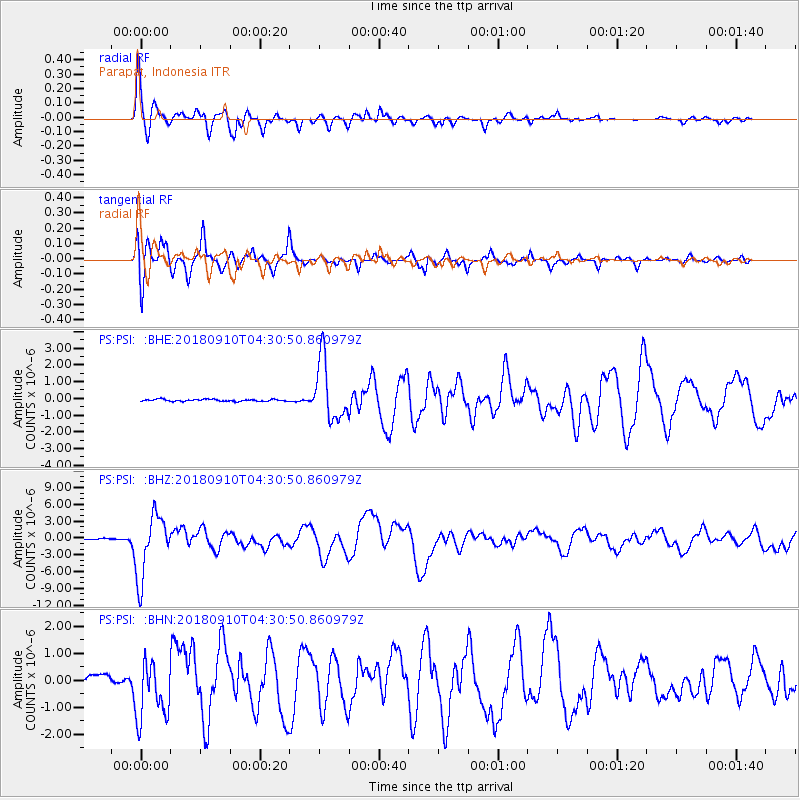
| Radial Match: |
93.4227 % |
| Radial Bump: |
400 |
| Transverse Match: |
93.81749 % |
| Transverse Bump: |
400 |
| SOD ConfigId: |
13570011 |
| Insert Time: |
2019-05-01 05:12:15.311 +0000 |
| GWidth: |
2.5 |
| Max Bumps: |
400 |
| Tol: |
0.001 |
|
Signal To Noise
| Channel | StoN | STA | LTA |
| PS:PSI: :BHZ:20180910T04:30:50.860979Z | 61.032238 | 5.579125E-6 | 9.1412765E-8 |
| PS:PSI: :BHN:20180910T04:30:50.860979Z | 8.36289 | 1.1031751E-6 | 1.3191314E-7 |
| PS:PSI: :BHE:20180910T04:30:50.860979Z | 29.465357 | 1.8095446E-6 | 6.1412614E-8 |
| Arrivals |
| Ps | 2.7 SECOND |
| PpPs | 9.3 SECOND |
| PsPs/PpSs | 12 SECOND |


