You are here: Home > Network List > TA - USArray Transportable Network (new EarthScope stations) Stations List
> Station E14A Clinton, MT, USA > Earthquake Result Viewer
E14A Clinton, MT, USA - Earthquake Result Viewer
| Earthquake location: |
Trinidad |
| Earthquake latitude/longitude: |
10.3/-60.4 |
| Earthquake time(UTC): |
2008/07/03 (185) 06:34:53 GMT |
| Earthquake Depth: |
34 km |
| Earthquake Magnitude: |
5.7 MB, 5.5 MS, 5.8 MW, 5.7 MW |
| Earthquake Catalog/Contributor: |
WHDF/NEIC |
|
| Network: |
TA USArray Transportable Network (new EarthScope stations) |
| Station: |
E14A Clinton, MT, USA |
| Lat/Lon: |
46.42 N/113.49 W |
| Elevation: |
1675 m |
|
| Distance: |
57.5 deg |
| Az: |
319.037 deg |
| Baz: |
111.163 deg |
| Ray Param: |
0.06339278 |
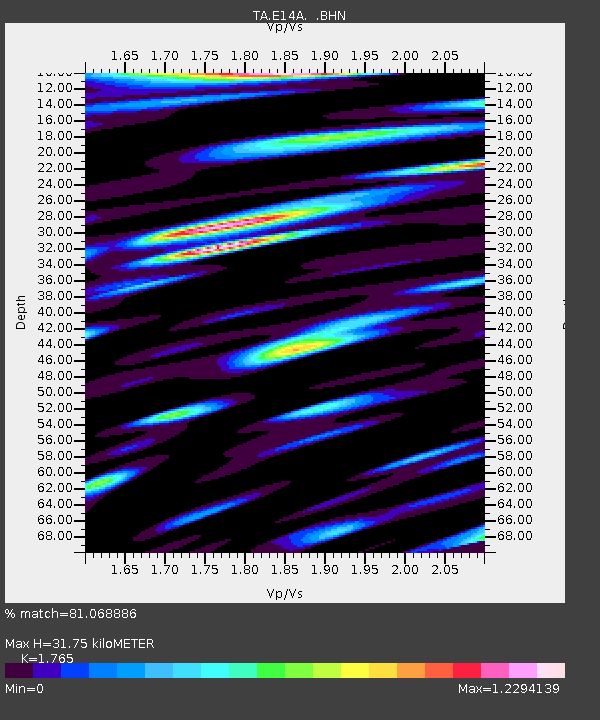
| Estimated Moho Depth: |
31.75 km |
| Estimated Crust Vp/Vs: |
1.76 |
| Assumed Crust Vp: |
6.353 km/s |
| Estimated Crust Vs: |
3.599 km/s |
| Estimated Crust Poisson's Ratio: |
0.26 |
|
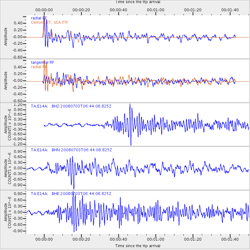
| Radial Match: |
81.068886 % |
| Radial Bump: |
400 |
| Transverse Match: |
63.53567 % |
| Transverse Bump: |
400 |
| SOD ConfigId: |
2504 |
| Insert Time: |
2010-03-06 15:43:14.739 +0000 |
| GWidth: |
2.5 |
| Max Bumps: |
400 |
| Tol: |
0.001 |
|
Signal To Noise
| Channel | StoN | STA | LTA |
| TA:E14A: :BHN:20080703T06:44:08.825Z | 2.2948403 | 1.4187529E-7 | 6.1823606E-8 |
| TA:E14A: :BHE:20080703T06:44:08.825Z | 1.1454571 | 6.269555E-8 | 5.4734084E-8 |
| TA:E14A: :BHZ:20080703T06:44:08.825Z | 1.616034 | 8.84522E-8 | 5.473412E-8 |
| Arrivals |
| Ps | 4.0 SECOND |
| PpPs | 13 SECOND |
| PsPs/PpSs | 17 SECOND |


