You are here: Home > Network List > S - Seismographs in Schools Projects Stations List
> Station AUAYR Ayr State High School, QLD > Earthquake Result Viewer
AUAYR Ayr State High School, QLD - Earthquake Result Viewer
| Earthquake location: |
Kermadec Islands Region |
| Earthquake latitude/longitude: |
-31.8/-179.3 |
| Earthquake time(UTC): |
2018/09/10 (253) 04:19:02 GMT |
| Earthquake Depth: |
111 km |
| Earthquake Magnitude: |
6.9 mww |
| Earthquake Catalog/Contributor: |
NEIC PDE/us |
|
| Network: |
S Seismographs in Schools Projects |
| Station: |
AUAYR Ayr State High School, QLD |
| Lat/Lon: |
19.58 S/147.41 E |
| Elevation: |
13 m |
|
| Distance: |
32.2 deg |
| Az: |
284.161 deg |
| Baz: |
118.931 deg |
| Ray Param: |
0.078442104 |
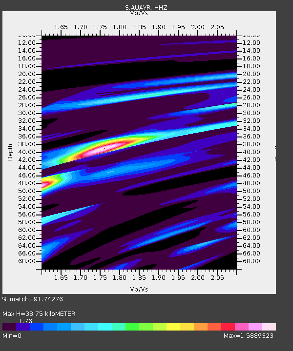
| Estimated Moho Depth: |
38.75 km |
| Estimated Crust Vp/Vs: |
1.76 |
| Assumed Crust Vp: |
6.472 km/s |
| Estimated Crust Vs: |
3.677 km/s |
| Estimated Crust Poisson's Ratio: |
0.26 |
|
| Radial Match: |
91.74276 % |
| Radial Bump: |
287 |
| Transverse Match: |
66.8179 % |
| Transverse Bump: |
400 |
| SOD ConfigId: |
13570011 |
| Insert Time: |
2019-05-01 05:12:35.125 +0000 |
| GWidth: |
2.5 |
| Max Bumps: |
400 |
| Tol: |
0.001 |
|

Signal To Noise
| Channel | StoN | STA | LTA |
| S:AUAYR: :HHZ:20180910T04:24:49.249987Z | 11.520848 | 1.1642265E-5 | 1.0105389E-6 |
| S:AUAYR: :HHN:20180910T04:24:49.249987Z | 4.2554064 | 3.7516713E-6 | 8.816247E-7 |
| S:AUAYR: :HHE:20180910T04:24:49.249987Z | 7.253421 | 6.6013545E-6 | 9.1010224E-7 |
| Arrivals |
| Ps | 4.9 SECOND |
| PpPs | 15 SECOND |
| PsPs/PpSs | 20 SECOND |


