You are here: Home > Network List > TA - USArray Transportable Network (new EarthScope stations) Stations List
> Station F15K North Star Ditch, AK, USA > Earthquake Result Viewer
F15K North Star Ditch, AK, USA - Earthquake Result Viewer
| Earthquake location: |
Kermadec Islands Region |
| Earthquake latitude/longitude: |
-31.8/-179.3 |
| Earthquake time(UTC): |
2018/09/10 (253) 04:19:02 GMT |
| Earthquake Depth: |
111 km |
| Earthquake Magnitude: |
6.9 mww |
| Earthquake Catalog/Contributor: |
NEIC PDE/us |
|
| Network: |
TA USArray Transportable Network (new EarthScope stations) |
| Station: |
F15K North Star Ditch, AK, USA |
| Lat/Lon: |
65.71 N/164.65 W |
| Elevation: |
388 m |
|
| Distance: |
97.9 deg |
| Az: |
6.078 deg |
| Baz: |
192.581 deg |
| Ray Param: |
0.03997898 |
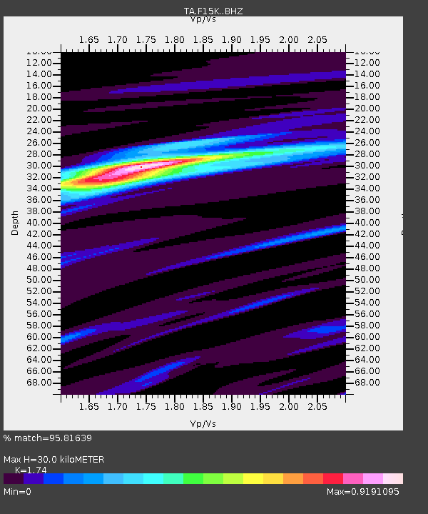
| Estimated Moho Depth: |
30.0 km |
| Estimated Crust Vp/Vs: |
1.74 |
| Assumed Crust Vp: |
6.276 km/s |
| Estimated Crust Vs: |
3.607 km/s |
| Estimated Crust Poisson's Ratio: |
0.25 |
|
| Radial Match: |
95.81639 % |
| Radial Bump: |
400 |
| Transverse Match: |
86.1328 % |
| Transverse Bump: |
400 |
| SOD ConfigId: |
13570011 |
| Insert Time: |
2019-05-01 05:12:51.807 +0000 |
| GWidth: |
2.5 |
| Max Bumps: |
400 |
| Tol: |
0.001 |
|

Signal To Noise
| Channel | StoN | STA | LTA |
| TA:F15K: :BHZ:20180910T04:31:53.474993Z | 30.762997 | 2.1634694E-6 | 7.0327005E-8 |
| TA:F15K: :BHN:20180910T04:31:53.474993Z | 11.377434 | 6.818314E-7 | 5.99284E-8 |
| TA:F15K: :BHE:20180910T04:31:53.474993Z | 4.8895135 | 2.026955E-7 | 4.145515E-8 |
| Arrivals |
| Ps | 3.6 SECOND |
| PpPs | 13 SECOND |
| PsPs/PpSs | 16 SECOND |


