You are here: Home > Network List > TA - USArray Transportable Network (new EarthScope stations) Stations List
> Station M20K Styx River, AK, USA > Earthquake Result Viewer
M20K Styx River, AK, USA - Earthquake Result Viewer
| Earthquake location: |
Kermadec Islands Region |
| Earthquake latitude/longitude: |
-31.8/-179.3 |
| Earthquake time(UTC): |
2018/09/10 (253) 04:19:02 GMT |
| Earthquake Depth: |
111 km |
| Earthquake Magnitude: |
6.9 mww |
| Earthquake Catalog/Contributor: |
NEIC PDE/us |
|
| Network: |
TA USArray Transportable Network (new EarthScope stations) |
| Station: |
M20K Styx River, AK, USA |
| Lat/Lon: |
61.88 N/153.13 W |
| Elevation: |
1107 m |
|
| Distance: |
95.8 deg |
| Az: |
12.137 deg |
| Baz: |
202.191 deg |
| Ray Param: |
0.040613234 |
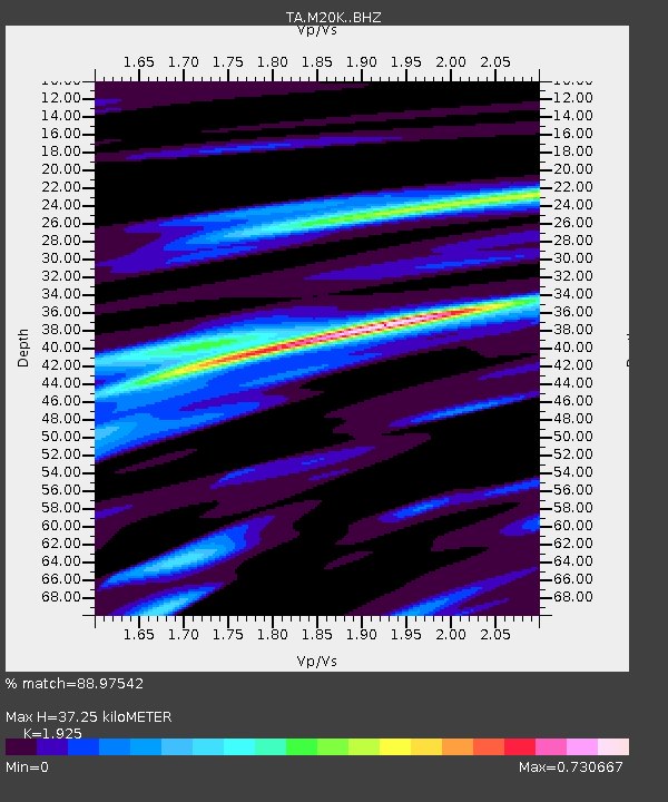
| Estimated Moho Depth: |
37.25 km |
| Estimated Crust Vp/Vs: |
1.92 |
| Assumed Crust Vp: |
6.566 km/s |
| Estimated Crust Vs: |
3.411 km/s |
| Estimated Crust Poisson's Ratio: |
0.32 |
|
| Radial Match: |
88.97542 % |
| Radial Bump: |
400 |
| Transverse Match: |
69.53371 % |
| Transverse Bump: |
400 |
| SOD ConfigId: |
13570011 |
| Insert Time: |
2019-05-01 05:13:17.868 +0000 |
| GWidth: |
2.5 |
| Max Bumps: |
400 |
| Tol: |
0.001 |
|

Signal To Noise
| Channel | StoN | STA | LTA |
| TA:M20K: :BHZ:20180910T04:31:44.000017Z | 23.888445 | 2.322265E-6 | 9.721289E-8 |
| TA:M20K: :BHN:20180910T04:31:44.000017Z | 9.036472 | 7.2304556E-7 | 8.001414E-8 |
| TA:M20K: :BHE:20180910T04:31:44.000017Z | 3.209732 | 2.3607141E-7 | 7.354864E-8 |
| Arrivals |
| Ps | 5.3 SECOND |
| PpPs | 16 SECOND |
| PsPs/PpSs | 22 SECOND |


