You are here: Home > Network List > TA - USArray Transportable Network (new EarthScope stations) Stations List
> Station E14A Clinton, MT, USA > Earthquake Result Viewer
E14A Clinton, MT, USA - Earthquake Result Viewer
*The percent match for this event was below the threshold and hence no stack was calculated.
| Earthquake location: |
Colombia |
| Earthquake latitude/longitude: |
4.3/-73.8 |
| Earthquake time(UTC): |
2008/05/24 (145) 19:20:42 GMT |
| Earthquake Depth: |
8.9 km |
| Earthquake Magnitude: |
5.6 MB, 5.6 MS, 5.9 MW, 5.9 MW |
| Earthquake Catalog/Contributor: |
WHDF/NEIC |
|
| Network: |
TA USArray Transportable Network (new EarthScope stations) |
| Station: |
E14A Clinton, MT, USA |
| Lat/Lon: |
46.42 N/113.49 W |
| Elevation: |
1675 m |
|
| Distance: |
54.2 deg |
| Az: |
326.969 deg |
| Baz: |
128.218 deg |
| Ray Param: |
$rayparam |
*The percent match for this event was below the threshold and hence was not used in the summary stack. |
|
| Radial Match: |
65.39863 % |
| Radial Bump: |
400 |
| Transverse Match: |
60.87047 % |
| Transverse Bump: |
400 |
| SOD ConfigId: |
2504 |
| Insert Time: |
2010-03-06 15:43:29.505 +0000 |
| GWidth: |
2.5 |
| Max Bumps: |
400 |
| Tol: |
0.001 |
|
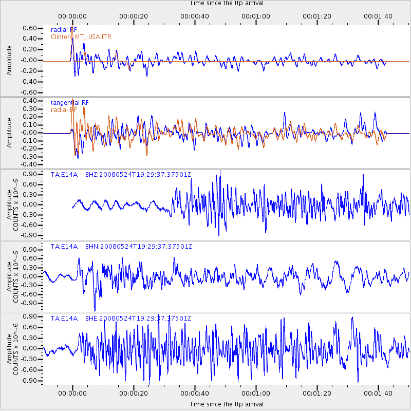
Signal To Noise
| Channel | StoN | STA | LTA |
| TA:E14A: :BHN:20080524T19:29:37.37501Z | 2.6089394 | 2.6524967E-7 | 1.01669535E-7 |
| TA:E14A: :BHE:20080524T19:29:37.37501Z | 2.1952648 | 2.2533683E-7 | 1.02646766E-7 |
| TA:E14A: :BHZ:20080524T19:29:37.37501Z | 2.5362723 | 2.109194E-7 | 8.316118E-8 |
| Arrivals |
| Ps | |
| PpPs | |
| PsPs/PpSs | |


