You are here: Home > Network List > TA - USArray Transportable Network (new EarthScope stations) Stations List
> Station M23K Glacier View, AK, USA > Earthquake Result Viewer
M23K Glacier View, AK, USA - Earthquake Result Viewer
| Earthquake location: |
Kermadec Islands Region |
| Earthquake latitude/longitude: |
-31.8/-179.3 |
| Earthquake time(UTC): |
2018/09/10 (253) 04:19:02 GMT |
| Earthquake Depth: |
111 km |
| Earthquake Magnitude: |
6.9 mww |
| Earthquake Catalog/Contributor: |
NEIC PDE/us |
|
| Network: |
TA USArray Transportable Network (new EarthScope stations) |
| Station: |
M23K Glacier View, AK, USA |
| Lat/Lon: |
61.79 N/147.73 W |
| Elevation: |
583 m |
|
| Distance: |
96.8 deg |
| Az: |
14.522 deg |
| Baz: |
206.69 deg |
| Ray Param: |
0.040330723 |
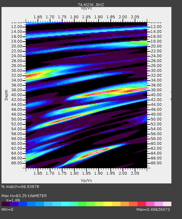
| Estimated Moho Depth: |
63.25 km |
| Estimated Crust Vp/Vs: |
1.89 |
| Assumed Crust Vp: |
6.566 km/s |
| Estimated Crust Vs: |
3.474 km/s |
| Estimated Crust Poisson's Ratio: |
0.31 |
|
| Radial Match: |
86.93979 % |
| Radial Bump: |
400 |
| Transverse Match: |
69.23447 % |
| Transverse Bump: |
400 |
| SOD ConfigId: |
13570011 |
| Insert Time: |
2019-05-01 05:13:20.846 +0000 |
| GWidth: |
2.5 |
| Max Bumps: |
400 |
| Tol: |
0.001 |
|

Signal To Noise
| Channel | StoN | STA | LTA |
| TA:M23K: :BHZ:20180910T04:31:48.39998Z | 31.906385 | 2.7968188E-6 | 8.765702E-8 |
| TA:M23K: :BHN:20180910T04:31:48.39998Z | 7.775163 | 6.7515066E-7 | 8.683428E-8 |
| TA:M23K: :BHE:20180910T04:31:48.39998Z | 4.726138 | 3.9056638E-7 | 8.263965E-8 |
| Arrivals |
| Ps | 8.7 SECOND |
| PpPs | 27 SECOND |
| PsPs/PpSs | 36 SECOND |


