You are here: Home > Network List > TA - USArray Transportable Network (new EarthScope stations) Stations List
> Station E14A Clinton, MT, USA > Earthquake Result Viewer
E14A Clinton, MT, USA - Earthquake Result Viewer
*The percent match for this event was below the threshold and hence no stack was calculated.
| Earthquake location: |
Iceland |
| Earthquake latitude/longitude: |
64.0/-21.0 |
| Earthquake time(UTC): |
2008/05/29 (150) 15:46:00 GMT |
| Earthquake Depth: |
10 km |
| Earthquake Magnitude: |
6.0 MB, 6.2 MS, 6.3 MW, 6.2 MW |
| Earthquake Catalog/Contributor: |
WHDF/NEIC |
|
| Network: |
TA USArray Transportable Network (new EarthScope stations) |
| Station: |
E14A Clinton, MT, USA |
| Lat/Lon: |
46.42 N/113.49 W |
| Elevation: |
1675 m |
|
| Distance: |
50.6 deg |
| Az: |
296.531 deg |
| Baz: |
34.744 deg |
| Ray Param: |
$rayparam |
*The percent match for this event was below the threshold and hence was not used in the summary stack. |
|
| Radial Match: |
69.29494 % |
| Radial Bump: |
400 |
| Transverse Match: |
65.80509 % |
| Transverse Bump: |
400 |
| SOD ConfigId: |
2504 |
| Insert Time: |
2010-03-06 15:43:30.777 +0000 |
| GWidth: |
2.5 |
| Max Bumps: |
400 |
| Tol: |
0.001 |
|
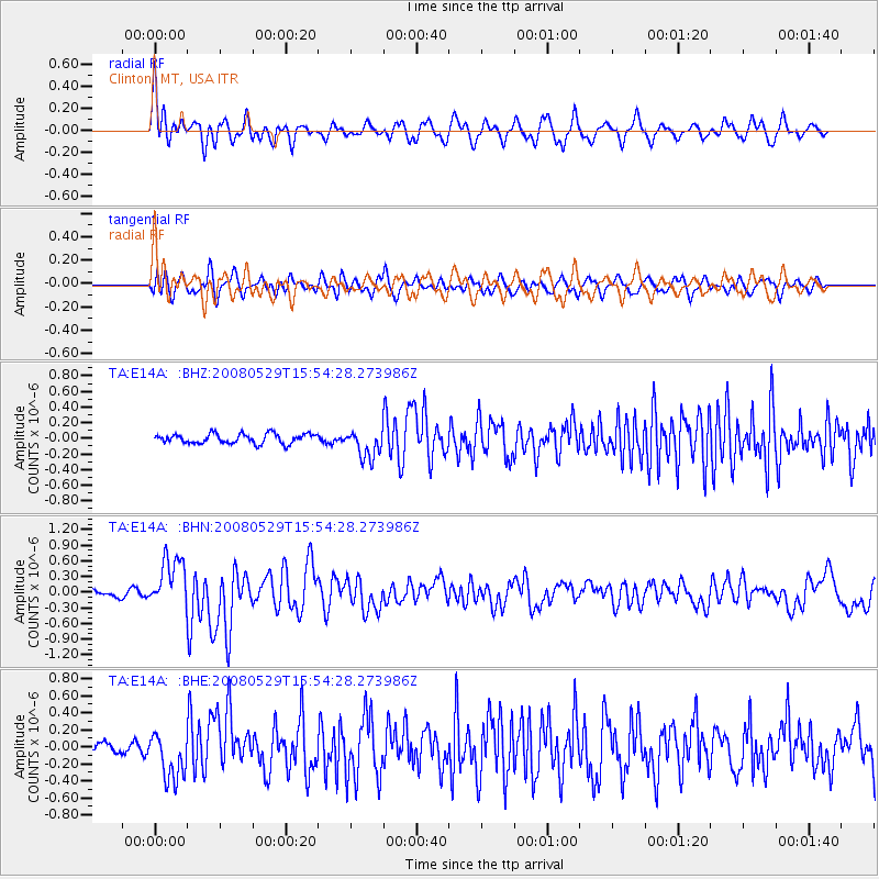
Signal To Noise
| Channel | StoN | STA | LTA |
| TA:E14A: :BHN:20080529T15:54:28.273986Z | 6.820891 | 4.8611037E-7 | 7.126787E-8 |
| TA:E14A: :BHE:20080529T15:54:28.273986Z | 3.8749676 | 2.7632439E-7 | 7.131011E-8 |
| TA:E14A: :BHZ:20080529T15:54:28.273986Z | 2.9632556 | 1.8246011E-7 | 6.1574205E-8 |
| Arrivals |
| Ps | |
| PpPs | |
| PsPs/PpSs | |


