You are here: Home > Network List > TA - USArray Transportable Network (new EarthScope stations) Stations List
> Station O15K Ungalikthiuk River, AK, USA > Earthquake Result Viewer
O15K Ungalikthiuk River, AK, USA - Earthquake Result Viewer
| Earthquake location: |
Kermadec Islands Region |
| Earthquake latitude/longitude: |
-31.8/-179.3 |
| Earthquake time(UTC): |
2018/09/10 (253) 04:19:02 GMT |
| Earthquake Depth: |
111 km |
| Earthquake Magnitude: |
6.9 mww |
| Earthquake Catalog/Contributor: |
NEIC PDE/us |
|
| Network: |
TA USArray Transportable Network (new EarthScope stations) |
| Station: |
O15K Ungalikthiuk River, AK, USA |
| Lat/Lon: |
59.18 N/159.82 W |
| Elevation: |
306 m |
|
| Distance: |
92.1 deg |
| Az: |
9.909 deg |
| Baz: |
196.524 deg |
| Ray Param: |
0.04145979 |
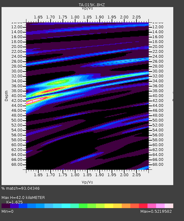
| Estimated Moho Depth: |
42.0 km |
| Estimated Crust Vp/Vs: |
1.62 |
| Assumed Crust Vp: |
6.24 km/s |
| Estimated Crust Vs: |
3.84 km/s |
| Estimated Crust Poisson's Ratio: |
0.20 |
|
| Radial Match: |
93.04346 % |
| Radial Bump: |
400 |
| Transverse Match: |
75.22089 % |
| Transverse Bump: |
400 |
| SOD ConfigId: |
13570011 |
| Insert Time: |
2019-05-01 05:13:28.229 +0000 |
| GWidth: |
2.5 |
| Max Bumps: |
400 |
| Tol: |
0.001 |
|

Signal To Noise
| Channel | StoN | STA | LTA |
| TA:O15K: :BHZ:20180910T04:31:27.325029Z | 38.741894 | 4.71904E-6 | 1.2180716E-7 |
| TA:O15K: :BHN:20180910T04:31:27.325029Z | 15.457237 | 1.4315435E-6 | 9.2613156E-8 |
| TA:O15K: :BHE:20180910T04:31:27.325029Z | 5.779945 | 5.0108696E-7 | 8.6694065E-8 |
| Arrivals |
| Ps | 4.3 SECOND |
| PpPs | 17 SECOND |
| PsPs/PpSs | 22 SECOND |


