You are here: Home > Network List > TA - USArray Transportable Network (new EarthScope stations) Stations List
> Station E14A Clinton, MT, USA > Earthquake Result Viewer
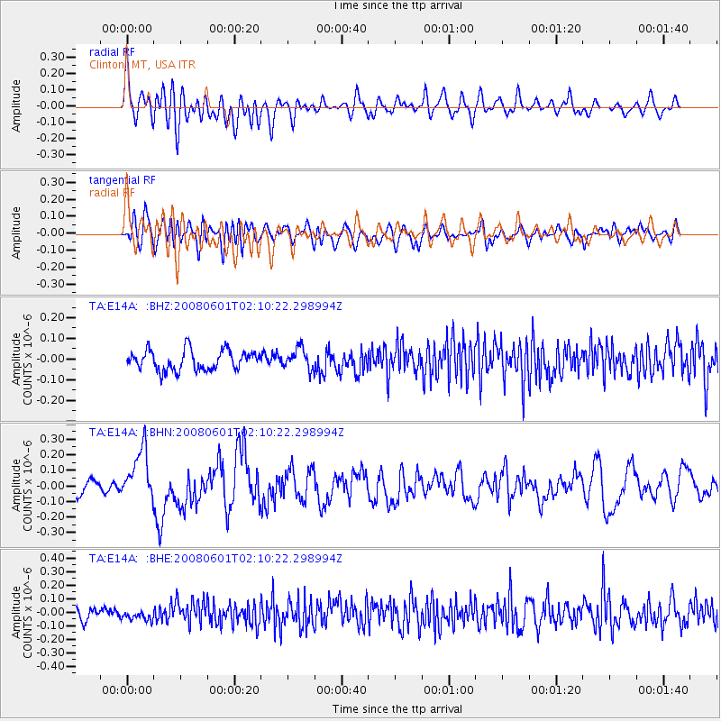
E14A Clinton, MT, USA - Earthquake Result Viewer
*The percent match for this event was below the threshold and hence no stack was calculated.
| Earthquake location: |
Philippine Islands Region |
| Earthquake latitude/longitude: |
20.1/121.4 |
| Earthquake time(UTC): |
2008/06/01 (153) 01:57:24 GMT |
| Earthquake Depth: |
35 km |
| Earthquake Magnitude: |
6.0 MB, 6.2 MS, 6.3 MW, 6.2 MW |
| Earthquake Catalog/Contributor: |
WHDF/NEIC |
|
| Network: |
TA USArray Transportable Network (new EarthScope stations) |
| Station: |
E14A Clinton, MT, USA |
| Lat/Lon: |
46.42 N/113.49 W |
| Elevation: |
1675 m |
|
| Distance: |
97.3 deg |
| Az: |
34.778 deg |
| Baz: |
309.219 deg |
| Ray Param: |
$rayparam |
*The percent match for this event was below the threshold and hence was not used in the summary stack. |
|
| Radial Match: |
69.3956 % |
| Radial Bump: |
400 |
| Transverse Match: |
55.956337 % |
| Transverse Bump: |
400 |
| SOD ConfigId: |
2504 |
| Insert Time: |
2010-03-06 15:43:32.974 +0000 |
| GWidth: |
2.5 |
| Max Bumps: |
400 |
| Tol: |
0.001 |
|
Signal To Noise
| Channel | StoN | STA | LTA |
| TA:E14A: :BHN:20080601T02:10:22.298994Z | 2.7072396 | 1.6713389E-7 | 6.17359E-8 |
| TA:E14A: :BHE:20080601T02:10:22.298994Z | 0.9038054 | 3.8941685E-8 | 4.3086363E-8 |
| TA:E14A: :BHZ:20080601T02:10:22.298994Z | 1.049771 | 5.0644296E-8 | 4.8243187E-8 |
| Arrivals |
| Ps | |
| PpPs | |
| PsPs/PpSs | |


