You are here: Home > Network List > NM - Cooperative New Madrid Seismic Network Stations List
> Station HBAR Harrisburg,AR(CERI) > Earthquake Result Viewer
HBAR Harrisburg,AR(CERI) - Earthquake Result Viewer
| Earthquake location: |
Northwest Of Kuril Islands |
| Earthquake latitude/longitude: |
47.7/147.0 |
| Earthquake time(UTC): |
2016/07/23 (205) 01:00:21 GMT |
| Earthquake Depth: |
407 km |
| Earthquake Magnitude: |
5.7 MB |
| Earthquake Catalog/Contributor: |
NEIC PDE/NEIC ALERT |
|
| Network: |
NM Cooperative New Madrid Seismic Network |
| Station: |
HBAR Harrisburg,AR(CERI) |
| Lat/Lon: |
35.56 N/90.66 W |
| Elevation: |
74 m |
|
| Distance: |
82.4 deg |
| Az: |
43.996 deg |
| Baz: |
324.877 deg |
| Ray Param: |
0.045787476 |
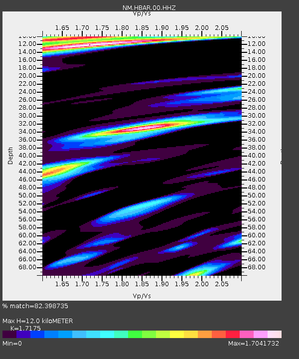
| Estimated Moho Depth: |
12.0 km |
| Estimated Crust Vp/Vs: |
1.72 |
| Assumed Crust Vp: |
6.273 km/s |
| Estimated Crust Vs: |
3.653 km/s |
| Estimated Crust Poisson's Ratio: |
0.24 |
|
| Radial Match: |
82.398735 % |
| Radial Bump: |
376 |
| Transverse Match: |
64.35869 % |
| Transverse Bump: |
400 |
| SOD ConfigId: |
1634031 |
| Insert Time: |
2016-08-06 01:11:09.157 +0000 |
| GWidth: |
2.5 |
| Max Bumps: |
400 |
| Tol: |
0.001 |
|

Signal To Noise
| Channel | StoN | STA | LTA |
| NM:HBAR:00:HHZ:20160723T01:11:27.825012Z | 10.16824 | 1.8349563E-6 | 1.8045958E-7 |
| NM:HBAR:00:HHN:20160723T01:11:27.825012Z | 3.524672 | 9.2593035E-7 | 2.6269973E-7 |
| NM:HBAR:00:HHE:20160723T01:11:27.825012Z | 5.2904887 | 1.5309223E-6 | 2.893726E-7 |
| Arrivals |
| Ps | 1.4 SECOND |
| PpPs | 5.1 SECOND |
| PsPs/PpSs | 6.5 SECOND |


