You are here: Home > Network List > UW - Pacific Northwest Regional Seismic Network Stations List
> Station WOLL Wollman Farm, Schrag, WA, USA > Earthquake Result Viewer
WOLL Wollman Farm, Schrag, WA, USA - Earthquake Result Viewer
| Earthquake location: |
Kermadec Islands Region |
| Earthquake latitude/longitude: |
-31.8/-179.3 |
| Earthquake time(UTC): |
2018/09/10 (253) 04:19:02 GMT |
| Earthquake Depth: |
111 km |
| Earthquake Magnitude: |
6.9 mww |
| Earthquake Catalog/Contributor: |
NEIC PDE/us |
|
| Network: |
UW Pacific Northwest Regional Seismic Network |
| Station: |
WOLL Wollman Farm, Schrag, WA, USA |
| Lat/Lon: |
47.06 N/118.92 W |
| Elevation: |
385 m |
|
| Distance: |
95.5 deg |
| Az: |
36.677 deg |
| Baz: |
228.033 deg |
| Ray Param: |
0.040686086 |
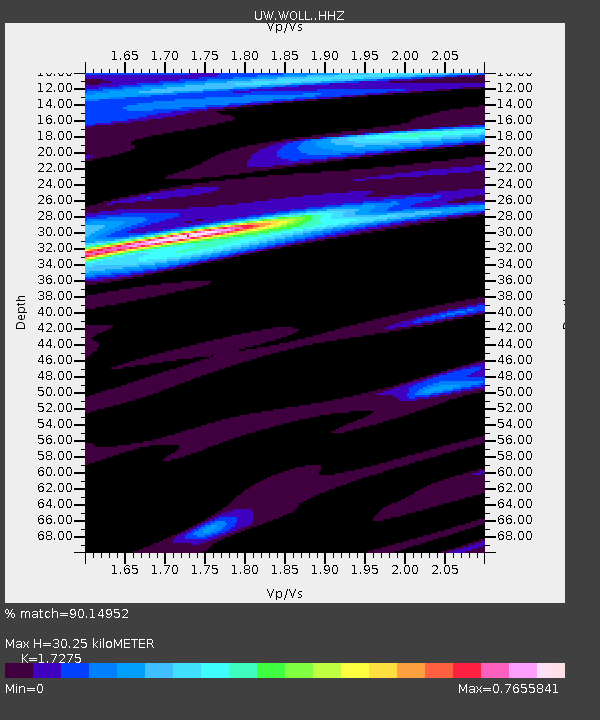
| Estimated Moho Depth: |
30.25 km |
| Estimated Crust Vp/Vs: |
1.73 |
| Assumed Crust Vp: |
6.419 km/s |
| Estimated Crust Vs: |
3.716 km/s |
| Estimated Crust Poisson's Ratio: |
0.25 |
|
| Radial Match: |
90.14952 % |
| Radial Bump: |
382 |
| Transverse Match: |
78.15521 % |
| Transverse Bump: |
366 |
| SOD ConfigId: |
13570011 |
| Insert Time: |
2019-05-01 05:15:11.911 +0000 |
| GWidth: |
2.5 |
| Max Bumps: |
400 |
| Tol: |
0.001 |
|

Signal To Noise
| Channel | StoN | STA | LTA |
| UW:WOLL: :HHZ:20180910T04:31:42.888018Z | 23.242619 | 3.6734425E-6 | 1.5804771E-7 |
| UW:WOLL: :HHN:20180910T04:31:42.888018Z | 3.4474134 | 5.46617E-7 | 1.5855858E-7 |
| UW:WOLL: :HHE:20180910T04:31:42.888018Z | 7.9336486 | 6.920919E-7 | 8.723501E-8 |
| Arrivals |
| Ps | 3.5 SECOND |
| PpPs | 13 SECOND |
| PsPs/PpSs | 16 SECOND |


