You are here: Home > Network List > YX16 - Raton Basin UNM Broadband Network Stations List
> Station UNM4 NW Corner of NM Stations > Earthquake Result Viewer
UNM4 NW Corner of NM Stations - Earthquake Result Viewer
| Earthquake location: |
Kermadec Islands Region |
| Earthquake latitude/longitude: |
-31.8/-179.3 |
| Earthquake time(UTC): |
2018/09/10 (253) 04:19:02 GMT |
| Earthquake Depth: |
111 km |
| Earthquake Magnitude: |
6.9 mww |
| Earthquake Catalog/Contributor: |
NEIC PDE/us |
|
| Network: |
YX Raton Basin UNM Broadband Network |
| Station: |
UNM4 NW Corner of NM Stations |
| Lat/Lon: |
36.99 N/105.06 W |
| Elevation: |
2784 m |
|
| Distance: |
97.5 deg |
| Az: |
51.012 deg |
| Baz: |
235.715 deg |
| Ray Param: |
0.040116783 |
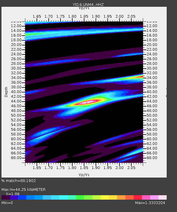
| Estimated Moho Depth: |
44.25 km |
| Estimated Crust Vp/Vs: |
1.86 |
| Assumed Crust Vp: |
6.316 km/s |
| Estimated Crust Vs: |
3.395 km/s |
| Estimated Crust Poisson's Ratio: |
0.30 |
|
| Radial Match: |
88.1902 % |
| Radial Bump: |
342 |
| Transverse Match: |
68.55816 % |
| Transverse Bump: |
400 |
| SOD ConfigId: |
13570011 |
| Insert Time: |
2019-05-01 05:15:22.537 +0000 |
| GWidth: |
2.5 |
| Max Bumps: |
400 |
| Tol: |
0.001 |
|

Signal To Noise
| Channel | StoN | STA | LTA |
| YX:UNM4: :HHZ:20180910T04:31:51.800005Z | 14.709734 | 1.6040289E-6 | 1.090454E-7 |
| YX:UNM4: :HHN:20180910T04:31:51.800005Z | 2.795942 | 3.5662433E-7 | 1.2755069E-7 |
| YX:UNM4: :HHE:20180910T04:31:51.800005Z | 4.4675364 | 4.5410675E-7 | 1.016459E-7 |
| Arrivals |
| Ps | 6.1 SECOND |
| PpPs | 20 SECOND |
| PsPs/PpSs | 26 SECOND |


