You are here: Home > Network List > TA - USArray Transportable Network (new EarthScope stations) Stations List
> Station E14A Clinton, MT, USA > Earthquake Result Viewer
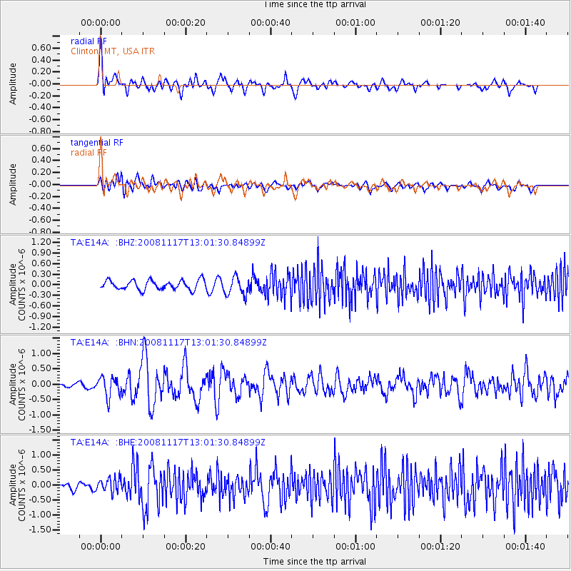
E14A Clinton, MT, USA - Earthquake Result Viewer
*The percent match for this event was below the threshold and hence no stack was calculated.
| Earthquake location: |
Arctic Ocean |
| Earthquake latitude/longitude: |
79.6/-116.1 |
| Earthquake time(UTC): |
2008/11/17 (322) 12:55:22 GMT |
| Earthquake Depth: |
7.0 km |
| Earthquake Magnitude: |
5.7 MW, 5.2 MS, 5.4 MB, 5.7 MW |
| Earthquake Catalog/Contributor: |
WHDF/NEIC |
|
| Network: |
TA USArray Transportable Network (new EarthScope stations) |
| Station: |
E14A Clinton, MT, USA |
| Lat/Lon: |
46.42 N/113.49 W |
| Elevation: |
1675 m |
|
| Distance: |
33.4 deg |
| Az: |
176.775 deg |
| Baz: |
359.157 deg |
| Ray Param: |
$rayparam |
*The percent match for this event was below the threshold and hence was not used in the summary stack. |
|
| Radial Match: |
64.930725 % |
| Radial Bump: |
400 |
| Transverse Match: |
57.613113 % |
| Transverse Bump: |
400 |
| SOD ConfigId: |
2658 |
| Insert Time: |
2010-03-06 15:44:08.141 +0000 |
| GWidth: |
2.5 |
| Max Bumps: |
400 |
| Tol: |
0.001 |
|
Signal To Noise
| Channel | StoN | STA | LTA |
| TA:E14A: :BHN:20081117T13:01:30.84899Z | 5.2502346 | 3.259025E-7 | 6.2073894E-8 |
| TA:E14A: :BHE:20081117T13:01:30.84899Z | 1.7411578 | 2.3051844E-7 | 1.3239377E-7 |
| TA:E14A: :BHZ:20081117T13:01:30.84899Z | 1.9713256 | 2.6056478E-7 | 1.3217743E-7 |
| Arrivals |
| Ps | |
| PpPs | |
| PsPs/PpSs | |


