You are here: Home > Network List > TA - USArray Transportable Network (new EarthScope stations) Stations List
> Station E14A Clinton, MT, USA > Earthquake Result Viewer
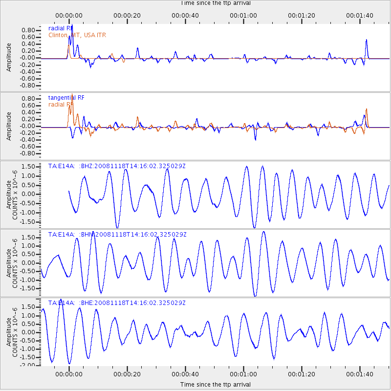
E14A Clinton, MT, USA - Earthquake Result Viewer
*The percent match for this event was below the threshold and hence no stack was calculated.
| Earthquake location: |
Vanuatu Islands |
| Earthquake latitude/longitude: |
-18.9/169.5 |
| Earthquake time(UTC): |
2008/11/18 (323) 14:03:15 GMT |
| Earthquake Depth: |
35 km |
| Earthquake Magnitude: |
5.5 MB, 5.3 MS, 5.5 MW |
| Earthquake Catalog/Contributor: |
WHDF/NEIC |
|
| Network: |
TA USArray Transportable Network (new EarthScope stations) |
| Station: |
E14A Clinton, MT, USA |
| Lat/Lon: |
46.42 N/113.49 W |
| Elevation: |
1675 m |
|
| Distance: |
94.9 deg |
| Az: |
42.583 deg |
| Baz: |
247.817 deg |
| Ray Param: |
$rayparam |
*The percent match for this event was below the threshold and hence was not used in the summary stack. |
|
| Radial Match: |
64.8883 % |
| Radial Bump: |
382 |
| Transverse Match: |
40.128983 % |
| Transverse Bump: |
400 |
| SOD ConfigId: |
2658 |
| Insert Time: |
2010-03-06 15:44:09.487 +0000 |
| GWidth: |
2.5 |
| Max Bumps: |
400 |
| Tol: |
0.001 |
|
Signal To Noise
| Channel | StoN | STA | LTA |
| TA:E14A: :BHN:20081118T14:16:02.325029Z | 1.8711983 | 8.908906E-7 | 4.76107E-7 |
| TA:E14A: :BHE:20081118T14:16:02.325029Z | 1.4865878 | 1.2033056E-6 | 8.0944136E-7 |
| TA:E14A: :BHZ:20081118T14:16:02.325029Z | 1.1814935 | 9.0894304E-7 | 7.6931696E-7 |
| Arrivals |
| Ps | |
| PpPs | |
| PsPs/PpSs | |


