You are here: Home > Network List > TA - USArray Transportable Network (new EarthScope stations) Stations List
> Station E14A Clinton, MT, USA > Earthquake Result Viewer
E14A Clinton, MT, USA - Earthquake Result Viewer
*The percent match for this event was below the threshold and hence no stack was calculated.
| Earthquake location: |
Mariana Islands |
| Earthquake latitude/longitude: |
19.1/145.8 |
| Earthquake time(UTC): |
2008/12/02 (337) 12:31:43 GMT |
| Earthquake Depth: |
137 km |
| Earthquake Magnitude: |
5.9 MB, 5.9 MW, 5.9 MW |
| Earthquake Catalog/Contributor: |
WHDF/NEIC |
|
| Network: |
TA USArray Transportable Network (new EarthScope stations) |
| Station: |
E14A Clinton, MT, USA |
| Lat/Lon: |
46.42 N/113.49 W |
| Elevation: |
1675 m |
|
| Distance: |
83.5 deg |
| Az: |
43.161 deg |
| Baz: |
290.783 deg |
| Ray Param: |
$rayparam |
*The percent match for this event was below the threshold and hence was not used in the summary stack. |
|
| Radial Match: |
43.971565 % |
| Radial Bump: |
400 |
| Transverse Match: |
65.56483 % |
| Transverse Bump: |
400 |
| SOD ConfigId: |
2658 |
| Insert Time: |
2010-03-06 15:44:18.005 +0000 |
| GWidth: |
2.5 |
| Max Bumps: |
400 |
| Tol: |
0.001 |
|
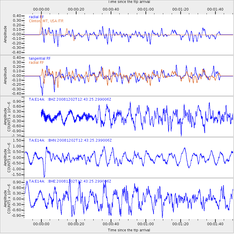
Signal To Noise
| Channel | StoN | STA | LTA |
| TA:E14A: :BHN:20081202T12:43:25.299006Z | 2.5630114 | 7.3417493E-7 | 2.8645013E-7 |
| TA:E14A: :BHE:20081202T12:43:25.299006Z | 0.5047092 | 2.9328098E-7 | 5.8108907E-7 |
| TA:E14A: :BHZ:20081202T12:43:25.299006Z | 1.4337705 | 3.008601E-7 | 2.0983839E-7 |
| Arrivals |
| Ps | |
| PpPs | |
| PsPs/PpSs | |


