You are here: Home > Network List > TA - USArray Transportable Network (new EarthScope stations) Stations List
> Station E14A Clinton, MT, USA > Earthquake Result Viewer
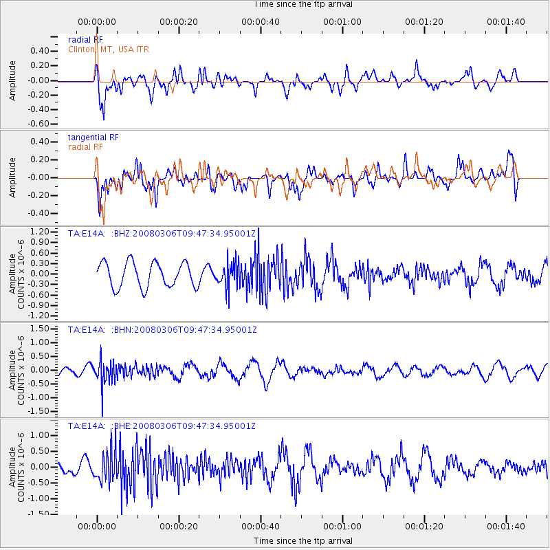
E14A Clinton, MT, USA - Earthquake Result Viewer
*The percent match for this event was below the threshold and hence no stack was calculated.
| Earthquake location: |
Kamchatka Peninsula, Russia |
| Earthquake latitude/longitude: |
51.5/156.5 |
| Earthquake time(UTC): |
2008/03/06 (066) 09:38:43 GMT |
| Earthquake Depth: |
134 km |
| Earthquake Magnitude: |
5.6 MB, 5.5 MW, 5.5 MW |
| Earthquake Catalog/Contributor: |
WHDF/NEIC |
|
| Network: |
TA USArray Transportable Network (new EarthScope stations) |
| Station: |
E14A Clinton, MT, USA |
| Lat/Lon: |
46.42 N/113.49 W |
| Elevation: |
1675 m |
|
| Distance: |
55.7 deg |
| Az: |
56.915 deg |
| Baz: |
310.831 deg |
| Ray Param: |
$rayparam |
*The percent match for this event was below the threshold and hence was not used in the summary stack. |
|
| Radial Match: |
52.77406 % |
| Radial Bump: |
400 |
| Transverse Match: |
52.3399 % |
| Transverse Bump: |
400 |
| SOD ConfigId: |
2504 |
| Insert Time: |
2010-03-06 15:44:30.654 +0000 |
| GWidth: |
2.5 |
| Max Bumps: |
400 |
| Tol: |
0.001 |
|
Signal To Noise
| Channel | StoN | STA | LTA |
| TA:E14A: :BHN:20080306T09:47:34.95001Z | 2.4015663 | 4.2935895E-7 | 1.7878288E-7 |
| TA:E14A: :BHE:20080306T09:47:34.95001Z | 2.6244013 | 4.840847E-7 | 1.8445529E-7 |
| TA:E14A: :BHZ:20080306T09:47:34.95001Z | 0.9598593 | 3.3939375E-7 | 3.5358698E-7 |
| Arrivals |
| Ps | |
| PpPs | |
| PsPs/PpSs | |


