You are here: Home > Network List > TA - USArray Transportable Network (new EarthScope stations) Stations List
> Station E14A Clinton, MT, USA > Earthquake Result Viewer
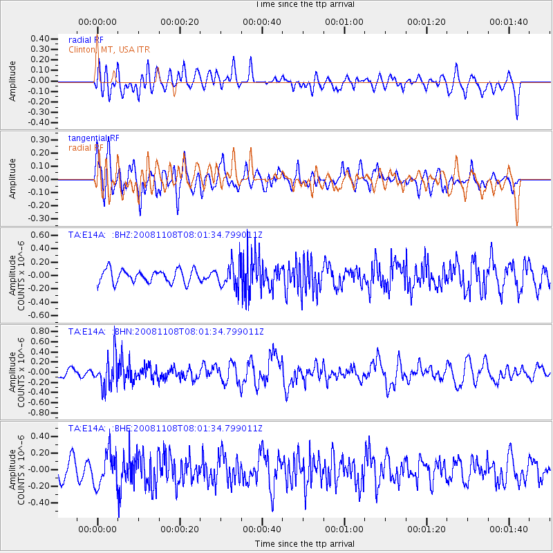
E14A Clinton, MT, USA - Earthquake Result Viewer
*The percent match for this event was below the threshold and hence no stack was calculated.
| Earthquake location: |
Tonga Islands |
| Earthquake latitude/longitude: |
-15.2/-174.2 |
| Earthquake time(UTC): |
2008/11/08 (313) 07:49:59 GMT |
| Earthquake Depth: |
121 km |
| Earthquake Magnitude: |
6.0 MW, 5.4 MB, 6.0 MW |
| Earthquake Catalog/Contributor: |
WHDF/NEIC |
|
| Network: |
TA USArray Transportable Network (new EarthScope stations) |
| Station: |
E14A Clinton, MT, USA |
| Lat/Lon: |
46.42 N/113.49 W |
| Elevation: |
1675 m |
|
| Distance: |
82.1 deg |
| Az: |
37.546 deg |
| Baz: |
238.247 deg |
| Ray Param: |
$rayparam |
*The percent match for this event was below the threshold and hence was not used in the summary stack. |
|
| Radial Match: |
45.07052 % |
| Radial Bump: |
400 |
| Transverse Match: |
57.000565 % |
| Transverse Bump: |
400 |
| SOD ConfigId: |
2658 |
| Insert Time: |
2010-03-06 15:44:31.582 +0000 |
| GWidth: |
2.5 |
| Max Bumps: |
400 |
| Tol: |
0.001 |
|
Signal To Noise
| Channel | StoN | STA | LTA |
| TA:E14A: :BHN:20081108T08:01:34.799011Z | 2.794566 | 3.055821E-7 | 1.09348676E-7 |
| TA:E14A: :BHE:20081108T08:01:34.799011Z | 1.828183 | 2.1057151E-7 | 1.15180754E-7 |
| TA:E14A: :BHZ:20081108T08:01:34.799011Z | 1.8678035 | 1.7956539E-7 | 9.61372E-8 |
| Arrivals |
| Ps | |
| PpPs | |
| PsPs/PpSs | |


