You are here: Home > Network List > AZ - ANZA Regional Network Stations List
> Station SMER AZ.SMER > Earthquake Result Viewer
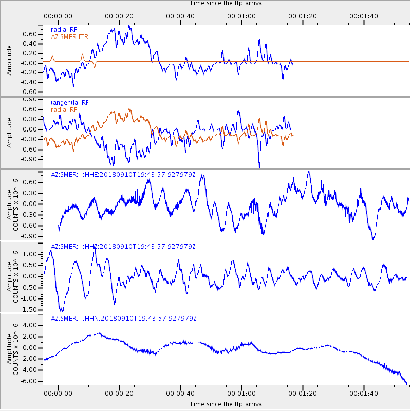
SMER AZ.SMER - Earthquake Result Viewer
*The percent match for this event was below the threshold and hence no stack was calculated.
| Earthquake location: |
Southeast Of Loyalty Islands |
| Earthquake latitude/longitude: |
-22.1/170.0 |
| Earthquake time(UTC): |
2018/09/10 (253) 19:31:42 GMT |
| Earthquake Depth: |
10 km |
| Earthquake Magnitude: |
6.6 Mi |
| Earthquake Catalog/Contributor: |
NEIC PDE/at |
|
| Network: |
AZ ANZA Regional Network |
| Station: |
SMER AZ.SMER |
| Lat/Lon: |
33.46 N/117.17 W |
| Elevation: |
355 m |
|
| Distance: |
88.6 deg |
| Az: |
53.03 deg |
| Baz: |
242.414 deg |
| Ray Param: |
$rayparam |
*The percent match for this event was below the threshold and hence was not used in the summary stack. |
|
| Radial Match: |
16.274643 % |
| Radial Bump: |
400 |
| Transverse Match: |
8.991412 % |
| Transverse Bump: |
400 |
| SOD ConfigId: |
13570011 |
| Insert Time: |
2019-05-01 05:18:35.761 +0000 |
| GWidth: |
2.5 |
| Max Bumps: |
400 |
| Tol: |
0.001 |
|
Signal To Noise
| Channel | StoN | STA | LTA |
| AZ:SMER: :HHZ:20180910T19:43:57.927979Z | 6.226843 | 9.415187E-7 | 1.5120321E-7 |
| AZ:SMER: :HHN:20180910T19:43:57.927979Z | 1.2446123 | 2.735369E-6 | 2.1977678E-6 |
| AZ:SMER: :HHE:20180910T19:43:57.927979Z | 0.60713464 | 1.5429885E-7 | 2.5414272E-7 |
| Arrivals |
| Ps | |
| PpPs | |
| PsPs/PpSs | |


