You are here: Home > Network List > TA - USArray Transportable Network (new EarthScope stations) Stations List
> Station E14A Clinton, MT, USA > Earthquake Result Viewer
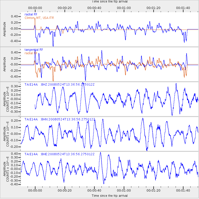
E14A Clinton, MT, USA - Earthquake Result Viewer
*The percent match for this event was below the threshold and hence no stack was calculated.
| Earthquake location: |
Solomon Islands |
| Earthquake latitude/longitude: |
-7.2/156.1 |
| Earthquake time(UTC): |
2008/05/24 (145) 13:24:05 GMT |
| Earthquake Depth: |
29 km |
| Earthquake Magnitude: |
5.8 MB, 5.5 MS, 5.9 MW, 5.8 MW |
| Earthquake Catalog/Contributor: |
WHDF/NEIC |
|
| Network: |
TA USArray Transportable Network (new EarthScope stations) |
| Station: |
E14A Clinton, MT, USA |
| Lat/Lon: |
46.42 N/113.49 W |
| Elevation: |
1675 m |
|
| Distance: |
95.4 deg |
| Az: |
44.024 deg |
| Baz: |
265.366 deg |
| Ray Param: |
$rayparam |
*The percent match for this event was below the threshold and hence was not used in the summary stack. |
|
| Radial Match: |
66.11683 % |
| Radial Bump: |
400 |
| Transverse Match: |
62.631466 % |
| Transverse Bump: |
384 |
| SOD ConfigId: |
2504 |
| Insert Time: |
2010-03-06 15:44:45.199 +0000 |
| GWidth: |
2.5 |
| Max Bumps: |
400 |
| Tol: |
0.001 |
|
Signal To Noise
| Channel | StoN | STA | LTA |
| TA:E14A: :BHN:20080524T13:36:56.275012Z | 0.59260803 | 6.320813E-8 | 1.06660934E-7 |
| TA:E14A: :BHE:20080524T13:36:56.275012Z | 0.991623 | 1.2472931E-7 | 1.2578299E-7 |
| TA:E14A: :BHZ:20080524T13:36:56.275012Z | 1.6864649 | 2.6275646E-7 | 1.558031E-7 |
| Arrivals |
| Ps | |
| PpPs | |
| PsPs/PpSs | |


